|
search place name
|
||
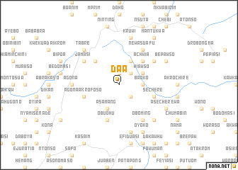
Daa (Ghana)Daa is a town in Ghana. An overview map of the region around Daa is displayed below.
regional and 3d topo map of Daa, Ghana ::
Daa airports ::
The nearest airport is NYI - Sunyani, located 111.3 km north west of Daa.
Other airports nearby include ACC - Accra Kotoka Intl (201.7 km south east), Nearby towns ::
Yawnso (1.9km north) //
Mampong Akrofoso (2.6km south east) //
Adichuem (2.6km north east) //
Banko (3.7km east) //
Asamang (4.1km south west) //
Wiawso (4.1km north east) //
Abayisua (4.1km north east) //
Apa (5.2km north west) //
Chichiwere (5.2km north west) //
Achwia (5.2km north east) //
Obuohu (5.9km south) //
Agona Akrofoso (5.8km west) //
Sechere (5.8km east) //
Oboming (6.7km south east) //
New Asuafu (6.7km north east) //
Jamasi (6.6km north west) //
Jansa (6.6km north east) //
Agona (7.4km west) //
Nsutem (7.6km south) //
Kruwi (7.6km north) //
Tabre (7.8km north west) //
Dewu (7.8km north west) //
Dadiasi (7.8km south east) //
Oyoko (8.3km south east) //
Asecherewa (8.2km south east) //
Bepawso (8.2km north east) //
Mantukwa (9.2km north east) //
[all distances 'as the bird flies' and approximate] 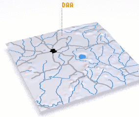 Places with similar names to Daa, Ghana ::
Disclaimer :: Information on this page comes without warranty of any kind |
||
|
Where is Daa? Elevation and coordinates ::
Latitude (lat): 6°56'0"N Longitude (lon): 1°25'0"W
Elevation (approx.): 311m (map arrows pan, magnifying glasses zoom) |
||
|
Visiting Daa? Hotel/Accommodation ::
Book a hotel in Daa Travel Guide ::
Buy a travel guide for Ghana rental cars ::
car rental offers GPS waypoint ::
download a GPX waypoint (PoI) of Daa for your GPS receiver
|
||