|
search place name
|
||
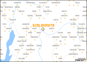
Dzolokpuita (Ghana)Dzolokpuita is a town in Ghana. An overview map of the region around Dzolokpuita is displayed below.
regional and 3d topo map of Dzolokpuita, Ghana ::
Dzolokpuita airports ::
The nearest airport is LFW - Lome Gnassingbe Eyadema Intl, located 114.8 km south east of Dzolokpuita.
Other airports nearby include ACC - Accra Kotoka Intl (147.9 km south west), COO - Cotonou Cadjehoun (221.3 km east), Nearby towns ::
Deme (2.6km south west) //
Agokpo (2.6km south west) //
Vane (2.6km north west) //
Djogbefeme (2.6km north west) //
Fiafe (3.7km west) //
Agate (3.7km east) //
Gbogame (4.1km north east) //
Gbota (4.1km north east) //
Gbogame (5.2km south west) //
Amedzofe (5.6km north) //
Konda (5.5km west) //
Biakpa (5.9km north) //
Agodome (5.8km west) //
Sroe (5.8km west) //
Gbogame (6.6km south east) //
Todze (6.6km north east) //
Emli (7.4km west) //
Odumasi (7.4km west) //
Gagbefe (7.6km west) //
Nyigbe (7.6km west) //
Tsome (7.6km south) //
Gbadjeme (7.6km north) //
Tsikoe (7.6km east) //
Aveha (7.6km east) //
Anfoeta Tsebi (7.8km south west) //
Agome (7.8km north west) //
Akovief (7.8km south east) //
Achame (8.2km south west) //
Agome (8.2km south west) //
[all distances 'as the bird flies' and approximate] 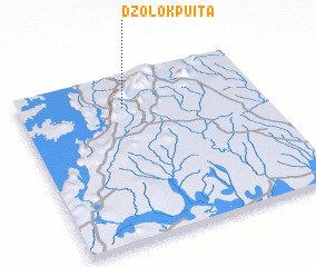 Places with similar names to Dzolokpuita, Ghana :: Disclaimer :: Information on this page comes without warranty of any kind |
||
|
Where is Dzolokpuita? Elevation and coordinates ::
Latitude (lat): 6°48'0"N Longitude (lon): 0°26'0"W
Elevation (approx.): 279m (map arrows pan, magnifying glasses zoom) |
||
|
Visiting Dzolokpuita? Hotel/Accommodation ::
Book a hotel in Dzolokpuita Travel Guide ::
Buy a travel guide for Ghana rental cars ::
car rental offers GPS waypoint ::
download a GPX waypoint (PoI) of Dzolokpuita for your GPS receiver
|
||