|
search place name
|
||
Gomoa Brofo (Ghana)Gomoa Brofo is a town in Ghana. An overview map of the region around Gomoa Brofo is displayed below.
regional and 3d topo map of Gomoa Brofo, Ghana ::

Gomoa Brofo airports ::
The nearest airport is ACC - Accra Kotoka Intl, located 81.9 km east of Gomoa Brofo.
Other airports nearby include TKD - Takoradi (113.3 km south west), NYI - Sunyani (273.6 km north west), Nearby towns ::
Nsumanu (0.0km north) //
Asempayin (1.8km west) //
Jaimanhu (1.9km north) //
Ebiramkwa (1.9km north) //
Asomanku (2.6km south west) //
Ngilisi (2.6km south east) //
Brebianu (4.1km north west) //
Gomoamem (4.1km south west) //
Ada (4.1km south east) //
Atakroasi (5.2km north west) //
Manso (5.2km south east) //
Chirin (5.2km south east) //
Odumasi (5.6km south) //
Atiandi (5.6km south) //
Otobiadzi (5.5km west) //
Ohua (5.5km east) //
Sachiri (5.9km south) //
Ghwiakrom (5.8km west) //
Adam (5.9km south) //
Atakwa (5.8km west) //
Akropong (5.9km north) //
Ampia Ajumako (6.7km north west) //
Dunkwa (6.7km north east) //
Faimaiya (6.7km south east) //
Ekrawfo (6.7km south west) //
Achiasi (6.7km north east) //
Abiadi Eshiem (7.4km north) //
Mando (7.6km west) //
Hamakwa (7.6km west) //
[all distances 'as the bird flies' and approximate] 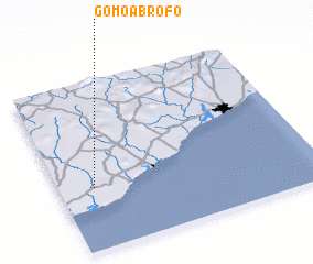 Places with similar names to Gomoa Brofo, Ghana :: Disclaimer :: Information on this page comes without warranty of any kind |
||
|
Where is Gomoa Brofo? Elevation and coordinates ::
Latitude (lat): 5°22'0"N Longitude (lon): 0°52'0"W
Elevation (approx.): 34m (map arrows pan, magnifying glasses zoom) |
||
|
Visiting Gomoa Brofo? Hotel/Accommodation ::
Book a hotel in Gomoa Brofo Travel Guide ::
Buy a travel guide for Ghana rental cars ::
car rental offers GPS waypoint ::
download a GPX waypoint (PoI) of Gomoa Brofo for your GPS receiver
|
||