|
search place name
|
||
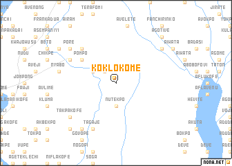
Koklokome (Ghana)Koklokome is a town in Ghana. An overview map of the region around Koklokome is displayed below.
regional and 3d topo map of Koklokome, Ghana ::
Koklokome airports ::
The nearest airport is ACC - Accra Kotoka Intl, located 86.0 km south west of Koklokome.
Other airports nearby include LFW - Lome Gnassingbe Eyadema Intl (109.7 km east), Nearby towns ::
Casave (2.6km north west) //
Nutekpo (3.7km south) //
Agbetiame (4.1km north west) //
Agawhaw (6.7km north west) //
Pompo (6.7km north west) //
Adapo (7.8km north west) //
Chibukofe (8.2km north west) //
Taga (8.3km south west) //
Tagaje (8.3km south west) //
Wuho (9.2km north east) //
Kluma (9.2km south west) //
Pore (9.2km north west) //
Avenong (9.2km north west) //
Takpakofe (9.2km south west) //
Agotive (10.5km north east) //
Gonyokofe (10.5km south west) //
[all distances 'as the bird flies' and approximate] 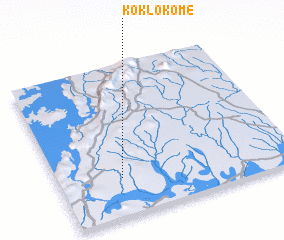 Places with similar names to Koklokome, Ghana ::
// Kukulegama (LK)
Disclaimer :: Information on this page comes without warranty of any kind |
||
|
Where is Koklokome? Elevation and coordinates ::
Latitude (lat): 6°15'0"N Longitude (lon): 0°16'0"W
Elevation (approx.): 49m (map arrows pan, magnifying glasses zoom) |
||
|
Visiting Koklokome? Hotel/Accommodation ::
Book a hotel in Koklokome Travel Guide ::
Buy a travel guide for Ghana rental cars ::
car rental offers GPS waypoint ::
download a GPX waypoint (PoI) of Koklokome for your GPS receiver
|
||