|
search place name
|
||
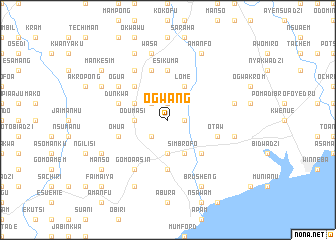
Ogwang (Ghana)Ogwang is a town in Ghana. An overview map of the region around Ogwang is displayed below.
regional and 3d topo map of Ogwang, Ghana ::
Ogwang airports ::
The nearest airport is ACC - Accra Kotoka Intl, located 70.9 km east of Ogwang.
Other airports nearby include TKD - Takoradi (124.1 km south west), NYI - Sunyani (278.8 km north west), Nearby towns ::
Abonku (1.9km north) //
Asakro (1.8km east) //
Nkoranza (2.6km south west) //
Damang (2.6km north west) //
Odumasi (3.7km west) //
Ajumako (3.7km south) //
Kumasi (4.1km north west) //
Simbrofo (4.1km south east) //
Lome (4.1km north east) //
Enyeme (5.2km north west) //
Odina (5.2km north west) //
Mprumem (5.2km south east) //
Esikuma (5.6km north) //
Ankamu (5.6km south) //
Dawurampong (5.9km north) //
Denchira (5.9km north) //
Ohua (5.8km west) //
Jukwa (5.8km east) //
Otaw (5.8km east) //
Dunkwa (5.8km west) //
Koforidua (6.7km north west) //
Gomoa Asin (6.7km south west) //
Ogua (6.7km north west) //
Pinanko (7.6km north) //
Wasa (7.6km north) //
Onyadzi (7.6km east) //
Kwatakrom (7.6km east) //
Ada (8.3km south west) //
Brofoyedru (8.3km south west) //
[all distances 'as the bird flies' and approximate] 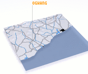 Places with similar names to Ogwang, Ghana ::
// Okwangai (UG)
Disclaimer :: Information on this page comes without warranty of any kind |
||
|
Where is Ogwang? Elevation and coordinates ::
Latitude (lat): 5°23'0"N Longitude (lon): 0°46'0"W
Elevation (approx.): 39m (map arrows pan, magnifying glasses zoom) |
||
|
Visiting Ogwang? Hotel/Accommodation ::
Book a hotel in Ogwang Travel Guide ::
Buy a travel guide for Ghana rental cars ::
car rental offers GPS waypoint ::
download a GPX waypoint (PoI) of Ogwang for your GPS receiver
|
||