|
search place name
|
||
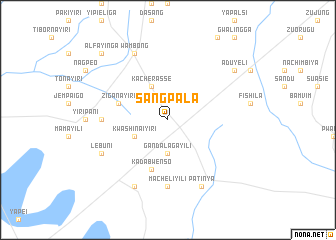
Sangpala (Ghana)Sangpala is a town in Ghana. An overview map of the region around Sangpala is displayed below.
regional and 3d topo map of Sangpala, Ghana ::
Sangpala airports ::
The nearest airport is TML - Tamale, located 36.3 km north east of Sangpala.
Other airports nearby include NYI - Sunyani (255.5 km south west), Nearby towns ::
Gandalagayili (3.7km south) //
Kacherasse (4.1km north west) //
Kwashinaiyiri (4.1km south west) //
Ziganayiri (5.8km west) //
Kadabwenso (5.9km south) //
Kwasero Daboshi (7.3km west) //
Macheliyili (7.4km south) //
Wambong (8.3km north west) //
Lebuni (8.2km south west) //
Kusawgu (8.3km south west) //
Patinya (8.3km south east) //
Aduyeli (9.2km north east) //
Barrayiri (10.4km north west) //
Alfayinga (10.4km north west) //
[all distances 'as the bird flies' and approximate] 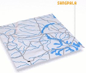 Places with similar names to Sangpala, Ghana ::
// Sungai Puloh (MY)
// Singaipalli (IN)
// Sangpolo (ID)
// Sangappale (LK)
// Sangpol (IR)
// Sangp'al-li (KR)
// Sangp'al-li (KP)
// Sangp'al-li (KP)
// Sangp'al-li (KP)
// Sangp'al-li (KP)
Disclaimer :: Information on this page comes without warranty of any kind |
||
|
Where is Sangpala? Elevation and coordinates ::
Latitude (lat): 9°16'0"N Longitude (lon): 1°1'0"W
Elevation (approx.): 150m (map arrows pan, magnifying glasses zoom) |
||
|
Visiting Sangpala? Hotel/Accommodation ::
Book a hotel in Sangpala Travel Guide ::
Buy a travel guide for Ghana rental cars ::
car rental offers GPS waypoint ::
download a GPX waypoint (PoI) of Sangpala for your GPS receiver
|
||