|
search place name
|
||
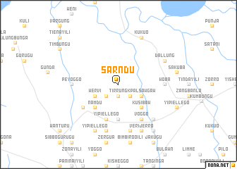
Sarndu (Ghana)Sarndu is a town in Ghana. An overview map of the region around Sarndu is displayed below.
regional and 3d topo map of Sarndu, Ghana ::
Sarndu airports ::
The nearest airport is TML - Tamale, located 22.5 km east of Sarndu.
Nearby towns ::
Tirrung (1.9km south) //
Gunda (2.6km south west) //
Kombonayili (2.6km south east) //
Wervi (4.1km south west) //
Kpalsawgaw (4.1km south east) //
Namdu (5.2km south west) //
Kusibaw (5.2km south east) //
Jebo (5.6km south) //
Yipiellego (5.9km south) //
Kasuridaborshi (6.6km south west) //
Voggo (6.7km south east) //
Peyoggo (7.3km west) //
Woba (7.3km east) //
Song (7.6km south) //
Binayili (7.6km south) //
Chantung (7.8km south east) //
Kasuri (8.3km south west) //
Yipiellego (8.3km south west) //
Verijerro (8.3km south east) //
Dallung (8.2km north east) //
Kukuo (8.3km north east) //
Guntassi (9.2km south east) //
[all distances 'as the bird flies' and approximate] 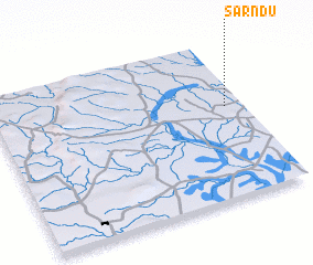 Places with similar names to Sarndu, Ghana ::
Disclaimer :: Information on this page comes without warranty of any kind |
||
|
Where is Sarndu? Elevation and coordinates ::
Latitude (lat): 9°35'0"N Longitude (lon): 1°4'0"W
Elevation (approx.): 154m (map arrows pan, magnifying glasses zoom) |
||
|
Visiting Sarndu? Hotel/Accommodation ::
Book a hotel in Sarndu Travel Guide ::
Buy a travel guide for Ghana rental cars ::
car rental offers GPS waypoint ::
download a GPX waypoint (PoI) of Sarndu for your GPS receiver
|
||