|
search place name
|
||
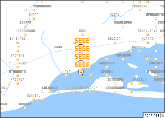
Sege (Ghana)Sege is a town in Ghana. An overview map of the region around Sege is displayed below.
regional and 3d topo map of Sege, Ghana ::
Sege airports ::
The nearest airport is ACC - Accra Kotoka Intl, located 63.3 km south west of Sege.
Other airports nearby include LFW - Lome Gnassingbe Eyadema Intl (106.0 km east), Nearby towns ::
Sege (1.9km north) //
Sege (1.9km south) //
Sege (3.7km south) //
Gedematukope (4.1km south east) //
Aplalu (4.1km north west) //
Minya (5.2km south west) //
Agedrafokope (5.5km east) //
Koni (5.6km north) //
Dawa (5.8km west) //
Adjomanikope (5.8km east) //
Songonya (5.8km east) //
Kposem (6.7km south east) //
Akplabanya (7.4km south) //
Wokumagbe (7.6km south) //
Anyamam (7.6km south) //
Omainkope (8.3km south west) //
Koloidaw (8.3km north east) //
Lekponguno (9.2km south west) //
Zutakope (9.2km south east) //
Luchubwe (10.5km south west) //
Goi (10.5km south east) //
Abuanokope (10.5km south east) //
[all distances 'as the bird flies' and approximate] 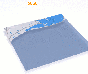 Places with similar names to Sege, Ghana ::
Disclaimer :: Information on this page comes without warranty of any kind |
||
|
Where is Sege? Elevation and coordinates ::
Latitude (lat): 5°51'0"N Longitude (lon): 0°21'0"W
Elevation (approx.): 6m (map arrows pan, magnifying glasses zoom) |
||
|
Visiting Sege? Hotel/Accommodation ::
Book a hotel in Sege Travel Guide ::
Buy a travel guide for Ghana rental cars ::
car rental offers GPS waypoint ::
download a GPX waypoint (PoI) of Sege for your GPS receiver
|
||