|
search place name
|
||
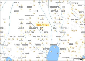
Tadzewu (Ghana)Tadzewu is a town in Ghana. An overview map of the region around Tadzewu is displayed below.
regional and 3d topo map of Tadzewu, Ghana ::
Tadzewu airports ::
The nearest airport is LFW - Lome Gnassingbe Eyadema Intl, located 39.3 km east of Tadzewu.
Other airports nearby include ACC - Accra Kotoka Intl (134.3 km south west), COO - Cotonou Cadjehoun (165.4 km east), Nearby towns ::
Avunu (1.9km south) //
Kuchinu (1.9km south) //
Pota (2.6km south east) //
Devergu (2.6km south east) //
Agodomi (3.7km south) //
Lume (3.7km west) //
Viglukofe (3.7km west) //
Tokpo (3.7km north) //
Hrife (4.1km south east) //
Hretologu (4.1km south west) //
Shagbovi (4.1km north west) //
Wuti (5.6km south) //
Ohawu (5.6km south) //
Achive (5.6km north) //
Tovi (5.5km east) //
Gadasukofe (5.5km west) //
Gefia (5.8km west) //
Akblokofe (5.8km west) //
Vume (5.9km south) //
Vojalogwi (5.9km north) //
Vachive (5.8km west) //
Safuchi (5.8km west) //
Jobafi (6.7km north east) //
Dadame (6.7km north west) //
Drefe (7.4km south) //
Bokuve (7.4km south) //
Anhyavekope (7.4km west) //
Tokanu (7.6km south) //
Deme (7.6km south) //
[all distances 'as the bird flies' and approximate] 
Disclaimer :: Information on this page comes without warranty of any kind |
||
|
Where is Tadzewu? Elevation and coordinates ::
Latitude (lat): 6°11'0"N Longitude (lon): 0°54'0"W
Elevation (approx.): 44m (map arrows pan, magnifying glasses zoom) |
||
|
Visiting Tadzewu? Hotel/Accommodation ::
Book a hotel in Tadzewu Travel Guide ::
Buy a travel guide for Ghana rental cars ::
car rental offers GPS waypoint ::
download a GPX waypoint (PoI) of Tadzewu for your GPS receiver
|
||