|
search place name
|
||
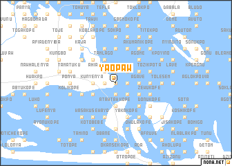
Yaopaw (Ghana)Yaopaw is a town in Ghana. An overview map of the region around Yaopaw is displayed below.
regional and 3d topo map of Yaopaw, Ghana ::
Yaopaw airports ::
The nearest airport is LFW - Lome Gnassingbe Eyadema Intl, located 78.9 km north east of Yaopaw.
Other airports nearby include ACC - Accra Kotoka Intl (90.3 km west), COO - Cotonou Cadjehoun (204.3 km east), Nearby towns ::
Akligbekope (0.0km north) //
Dedekope (1.9km south) //
Tomivawkope (1.8km west) //
Jetokwe (1.9km north) //
Akwekope (1.8km east) //
Avegoeme (1.8km east) //
Glume (2.6km south east) //
Kpajakope (2.6km north west) //
Ahiamajikope (2.6km north west) //
Sondo (2.6km north east) //
Agave (3.7km east) //
Kunyenya (3.7km west) //
Tawvi (3.7km east) //
Bwetakope (3.7km west) //
Atawtawkope (3.7km south) //
Dongwam (4.1km south west) //
Ajake (4.1km south east) //
Avegagome (4.1km north east) //
Asidowui (4.1km north east) //
Tamlago (4.1km north west) //
Chachukope (5.2km south east) //
Agovlayakope (5.2km north east) //
Nubwakope (5.2km north west) //
Agome (5.2km north east) //
Womenyi (5.6km north) //
Nutekpo (5.5km east) //
Ziwenu (5.5km east) //
Dogo (5.8km west) //
Zewukofe (5.8km east) //
[all distances 'as the bird flies' and approximate]  Places with similar names to Yaopaw, Ghana ::
Disclaimer :: Information on this page comes without warranty of any kind |
||
|
Where is Yaopaw? Elevation and coordinates ::
Latitude (lat): 5°53'0"N Longitude (lon): 0°36'0"W
Elevation (approx.): 9m (map arrows pan, magnifying glasses zoom) |
||
|
Visiting Yaopaw? Hotel/Accommodation ::
Book a hotel in Yaopaw Travel Guide ::
Buy a travel guide for Ghana rental cars ::
car rental offers GPS waypoint ::
download a GPX waypoint (PoI) of Yaopaw for your GPS receiver
|
||