|
search place name
|
||
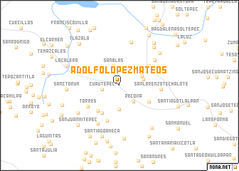
Adolfo López Mateos (Tlaxcala, Mexico)Adolfo López Mateos is a town in the Tlaxcala region of Mexico. An overview map of the region around Adolfo López Mateos is displayed below.
regional and 3d topo map of Adolfo López Mateos, Mexico ::
Adolfo López Mateos airports ::
The nearest airport is TXA - Tlaxcala, located 23.2 km east of Adolfo López Mateos.
Other airports nearby include PBC - Puebla Hermanos Serdan Intl (38.5 km south), MEX - Mexico City Licenciado Benito Juarez Intl (71.9 km west), PCA - Pachuca Ingeniero Juan Guillermo Villasana (75.4 km north west), CVJ - Cuernavaca General Mariano Matamoros (117.8 km south west), Nearby towns ::
Cuautepec (2.7km west) //
San Blas (3.2km north) //
Recova (3.2km south east) //
Miguel Aldama (3.7km south) //
Santa María (3.6km east) //
La Loma (3.7km north east) //
Españita (5.1km south west) //
Hueyotlipan de Hidalgo (5.0km south east) //
San Miguel (5.1km south west) //
San Antonio Techalote (5.3km north east) //
Las Pilas (5.9km south) //
Torres (5.7km south west) //
San Lorenzo Techalote (6.1km east) //
Santo Tomás (6.6km north east) //
El Carmen (6.8km south west) //
Ignacio Zaragoza (7.0km north) //
La Magdalena Cuestotitla (7.5km south west) //
La Gasapera (7.9km north east) //
La Providencia (7.8km north east) //
Sanctórum (7.9km west) //
Las Carrozas (8.2km south east) //
San Miguel Tepalc (8.4km south) //
Santiago Ameca (8.4km south) //
San Felipe (8.4km north east) //
La Calera (8.4km west) //
San Juan Mitepec (8.7km south west) //
La Constancia (9.0km south) //
Tlazala (8.8km north west) //
El Santísimo (9.0km north east) //
[all distances 'as the bird flies' and approximate] 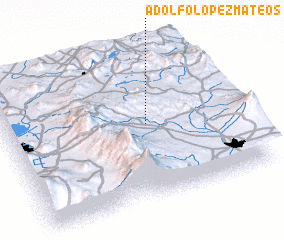 Places with similar names to Adolfo López Mateos, Mexico ::
// Adolfo López Mateos (MX)
// Adolfo López Mateos (MX)
// Adolfo López Mateos (MX)
// Adolfo López Mateos (MX)
// Adolfo López Mateos (MX)
// Adolfo López Mateos (MX)
// Adolfo López Mateos (MX)
// Adolfo López Mateos (MX)
// Adolfo López Mateos (MX)
// Adolfo López Mateos (MX)
Disclaimer :: Information on this page comes without warranty of any kind |
||
|
Where is Adolfo López Mateos? Elevation and coordinates ::
Latitude (lat): 19°30'20"N Longitude (lon): 98°23'30"W
Elevation (approx.): 2629m (map arrows pan, magnifying glasses zoom) |
||
|
Visiting Adolfo López Mateos? Hotel/Accommodation ::
Book a hotel in Adolfo López Mateos Travel Guide ::
Buy a travel guide for Mexico rental cars ::
car rental offers GPS waypoint ::
download a GPX waypoint (PoI) of Adolfo López Mateos for your GPS receiver
|
||