|
search place name
|
||
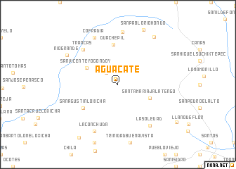
Aguacate (Oaxaca, Mexico)Aguacate is a town in the Oaxaca region of Mexico. An overview map of the region around Aguacate is displayed below.
regional and 3d topo map of Aguacate, Mexico ::
Aguacate airports ::
The nearest airport is HUX - Bahias Dehuatulco Bahias De Huatulco Intl, located 45.9 km south east of Aguacate.
Other airports nearby include PXM - Puerto Escondido Intl (57.4 km west), OAX - Oaxaca Xoxocotlan Intl (106.2 km north), Nearby towns ::
San Vicente (2.6km north west) //
La Paz Obisbo (2.7km north west) //
Santa María Jalatengo (5.3km south east) //
San Vicente Yogondoy (5.5km north west) //
Guachepil (6.3km north) //
San Agustín Loxicha (6.5km south west) //
Trancas (7.7km north west) //
La Soledad (8.1km south east) //
Cofradía (8.2km north west) //
La Conchuda (8.2km south west) //
La Victoria (8.4km north) //
Río Grande (9.1km north west) //
La Doncella (9.3km north east) //
San Pablo Río Hondo (9.5km north east) //
Tierra Blanca (10.4km south west) //
[all distances 'as the bird flies' and approximate] 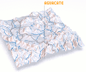 Places with similar names to Aguacate, Mexico ::
Disclaimer :: Information on this page comes without warranty of any kind |
||
|
Where is Aguacate? Elevation and coordinates ::
Latitude (lat): 16°3'0"N Longitude (lon): 96°35'0"W
Elevation (approx.): 1862m (map arrows pan, magnifying glasses zoom) |
||
|
Visiting Aguacate? Hotel/Accommodation ::
Book a hotel in Aguacate Travel Guide ::
Buy a travel guide for Mexico rental cars ::
car rental offers GPS waypoint ::
download a GPX waypoint (PoI) of Aguacate for your GPS receiver
|
||