|
search place name
|
||
Alvaro Obregón (México, Mexico)Alvaro Obregón is a town in the México region of Mexico. An overview map of the region around Alvaro Obregón is displayed below.
regional and 3d topo map of Alvaro Obregón, Mexico ::

Alvaro Obregón airports ::
The nearest airport is PCA - Pachuca Ingeniero Juan Guillermo Villasana, located 36.6 km north of Alvaro Obregón.
Other airports nearby include MEX - Mexico City Licenciado Benito Juarez Intl (41.2 km south west), TXA - Tlaxcala (77.5 km east), PBC - Puebla Hermanos Serdan Intl (84.9 km south east), TLC - Toluca Licenciado Adolfo Lopez Mateos Intl (86.2 km south west), Nearby towns ::
San Luis Tecuautitlán (0.6km north west) //
Tezompa (0.9km south) //
San Agustín Actipan (4.1km south west) //
Santa Ana Tlachihualpa (4.5km west) //
San Antonio de las Palmas (5.3km south east) //
Santa María Maquixco (5.2km north east) //
Santa María Palapa (5.2km south east) //
San Juan Bautista Teacalco (5.3km north east) //
Teopancala (5.6km north) //
San Miguel Atlamaja (6.2km west) //
San Jerónimo Xonacahuacán (6.2km west) //
San Cristóbal Colhuacán (6.4km east) //
San Isidro (7.1km south west) //
San Pablo Ixquitlán (7.1km south east) //
San José Cerro Gordo (7.1km south east) //
San Martín de las Pirámides (7.8km south east) //
Tzacualocan (7.8km south west) //
Paula (7.7km north west) //
San Bartolo Actopan (8.3km north) //
San Juan Teotihuacán (8.4km south) //
Maquixco (8.4km south) //
Santo Domingo Ajolcapan (7.9km west) //
Francisco Mazapa (8.3km south east) //
Temascalapa (8.7km north) //
Santiago Zacualuca (8.9km south west) //
La Carranza (8.9km north west) //
Huitzila (8.9km north west) //
San Miguel (9.1km south west) //
Santa María Coatlán (9.8km south east) //
[all distances 'as the bird flies' and approximate] 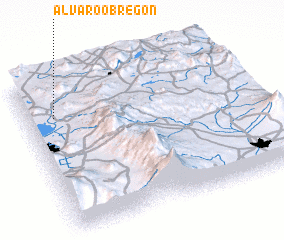 Places with similar names to Alvaro Obregón, Mexico ::
// Álvaro Obregón (MX)
// Álvaro Obregón (MX)
// Álvaro Obregón (MX)
// Álvaro Obregón (MX)
// Álvaro Obregón (MX)
// Álvaro Obregón (MX)
// Álvaro Obregón (MX)
// Álvaro Obregón (MX)
// Álvaro Obregón (MX)
// Álvaro Obregón (MX)
Disclaimer :: Information on this page comes without warranty of any kind |
||
|
Where is Alvaro Obregón? Elevation and coordinates ::
Latitude (lat): 19°45'30"N Longitude (lon): 98°52'30"W
Elevation (approx.): 2521m (map arrows pan, magnifying glasses zoom) |
||
|
Visiting Alvaro Obregón? Hotel/Accommodation ::
Book a hotel in Alvaro Obregón Travel Guide ::
Buy a travel guide for Mexico rental cars ::
car rental offers GPS waypoint ::
download a GPX waypoint (PoI) of Alvaro Obregón for your GPS receiver
|
||