|
search place name
|
||
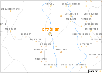
Atzalan (Veracruz-Llave, Mexico)Atzalan is a town in the Veracruz-Llave region of Mexico. An overview map of the region around Atzalan is displayed below.
regional and 3d topo map of Atzalan, Mexico ::
Atzalan airports ::
The nearest airport is PAZ - Poza Rico Tajin, located 92.5 km north of Atzalan.
Other airports nearby include TXA - Tlaxcala (104.4 km west), VER - Vera Cruz General Heriberto Jara Intl (130.1 km south east), PBC - Puebla Hermanos Serdan Intl (140.5 km south west), TCN - Tehuacan (145.8 km south), Nearby towns ::
Altotonga (4.1km south west) //
Xoampolco (4.1km south east) //
Texacaxco (5.1km south west) //
Ahuacatán (5.6km west) //
Juan Marcos (6.6km south west) //
Chichicapa (6.6km south east) //
Xiocuilapa (8.2km north east) //
Tazolapa (8.9km north east) //
Chachalaca (10.2km north east) //
[all distances 'as the bird flies' and approximate] 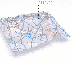 Places with similar names to Atzalan, Mexico :: Disclaimer :: Information on this page comes without warranty of any kind |
||
|
Where is Atzalan? Elevation and coordinates ::
Latitude (lat): 19°48'0"N Longitude (lon): 97°13'0"W
Elevation (approx.): 1598m (map arrows pan, magnifying glasses zoom) |
||
|
Visiting Atzalan? Hotel/Accommodation ::
Book a hotel in Atzalan Travel Guide ::
Buy a travel guide for Mexico rental cars ::
car rental offers GPS waypoint ::
download a GPX waypoint (PoI) of Atzalan for your GPS receiver
|
||