|
search place name
|
||
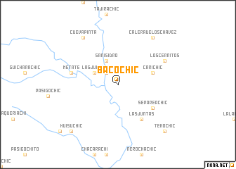
Bacóchic (Chihuahua, Mexico)Bacóchic is a town in the Chihuahua region of Mexico. An overview map of the region around Bacóchic is displayed below.
regional and 3d topo map of Bacóchic, Mexico ::
Bacóchic airports ::
The nearest airport is CUU - Chihuahua General R Fierro Villalobos Intl, located 141.4 km north east of Bacóchic.
Nearby towns ::
Las Juntas de Bocachi (2.5km north west) //
Baporachic (3.8km north west) //
San Isidro (4.1km north west) //
Arroyo de Agua (5.3km east) //
Carichic (5.3km east) //
La Mesa (6.5km south east) //
Las Juntas (6.5km south east) //
Separeachic (6.2km south east) //
Metate (6.8km west) //
Los Cerritos (7.5km north east) //
Calera de los Chávez (8.9km north east) //
Cueva Pinta (8.9km north west) //
Babuchique (9.9km south west) //
Temochic (9.9km south east) //
Huisuchic (9.9km south west) //
[all distances 'as the bird flies' and approximate] 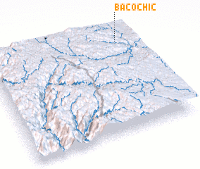 Places with similar names to Bacóchic, Mexico ::
// Bagtiag (PH)
// Bocachica (PH)
// Boca Chica (PA)
// Bogachka (UA)
// Boca Chica (CO)
// Bocachica (CO)
// Bocachica (CO)
// Bocachico (CO)
// Boca Chica (EC)
// Bucay Chico (EC)
Disclaimer :: Information on this page comes without warranty of any kind |
||
|
Where is Bacóchic? Elevation and coordinates ::
Latitude (lat): 27°55'0"N Longitude (lon): 107°6'0"W
Elevation (approx.): 2115m (map arrows pan, magnifying glasses zoom) |
||
|
Visiting Bacóchic? Hotel/Accommodation ::
Book a hotel in Bacóchic Travel Guide ::
Buy a travel guide for Mexico rental cars ::
car rental offers GPS waypoint ::
download a GPX waypoint (PoI) of Bacóchic for your GPS receiver
|
||