|
search place name
|
||
Buenavista (Sonora, Mexico)Buenavista is a town in the Sonora region of Mexico. An overview map of the region around Buenavista is displayed below.
regional and 3d topo map of Buenavista, Mexico ::

Buenavista airports ::
The nearest airport is CEN - Ciudad Obregon Intl, located 50.8 km south of Buenavista.
Other airports nearby include GYM - Guaymas General Jose Maria Yanez Intl (105.0 km west), HMO - Hermosillo General Ignacio P Garcia Intl (180.1 km north west), LTO - Loreto Intl (253.3 km south west), Nearby towns ::
Llano (1.9km north) //
Ranchito (1.9km south) //
Marina del Rey (2.5km south west) //
El Disparate (2.5km south east) //
Huamúchil (4.1km north east) //
Huamúchiles (4.9km south west) //
Potrero (4.9km south west) //
El Ranchito (5.8km south) //
Pima (6.5km south west) //
Cuevas (6.5km south west) //
Tres Cerritos (6.5km north east) //
San Isidro (6.5km north east) //
[all distances 'as the bird flies' and approximate] 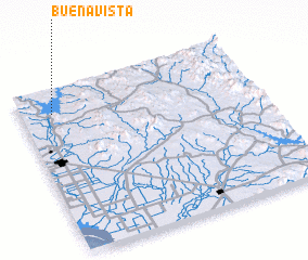 Places with similar names to Buenavista, Mexico ::
// Buenavista (PH)
// Buenavista (PH)
// Buenavista (PH)
// Buenavista (PH)
// Buenavista (PH)
// Buena Vista (PH)
// Buena Vista (PH)
// Buena Vista (PH)
// Buenavista (PH)
// Buenavista (PH)
Disclaimer :: Information on this page comes without warranty of any kind |
||
|
Where is Buenavista? Elevation and coordinates ::
Latitude (lat): 27°51'0"N Longitude (lon): 109°52'0"W
Elevation (approx.): 70m (map arrows pan, magnifying glasses zoom) |
||
|
Visiting Buenavista? Hotel/Accommodation ::
Book a hotel in Buenavista Travel Guide ::
Buy a travel guide for Mexico rental cars ::
car rental offers GPS waypoint ::
download a GPX waypoint (PoI) of Buenavista for your GPS receiver
|
||