|
search place name
|
||
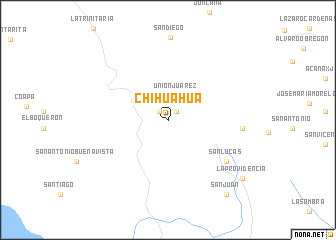
Chihuahua (Chiapas, Mexico)Chihuahua is a town in the Chiapas region of Mexico. An overview map of the region around Chihuahua is displayed below.
regional and 3d topo map of Chihuahua, Mexico ::
Chihuahua airports ::
The nearest airport is TGZ - Tuxtla Gutierrez Angel Albino Corzo, located 127.1 km north west of Chihuahua.
Other airports nearby include TAP - Tapachula Intl (142.6 km south), CBV - Coban (179.0 km east), GUA - Guatemala City La Aurora (222.7 km south east), VSA - Villahermosa C P A Carlos Rovirosa Intl (236.0 km north), Nearby towns ::
San Pedro (1.3km north east) //
Rosario (1.3km north west) //
Unión Juárez (2.9km north) //
San Lucas (7.8km south east) //
Ángel Alvino Corzo (8.1km east) //
La Providencia (10.3km south east) //
San Juan (10.4km south east) //
[all distances 'as the bird flies' and approximate] 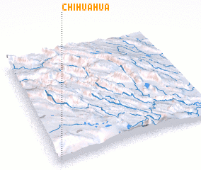 Places with similar names to Chihuahua, Mexico ::
// Chihuahua (US)
// Chihuahua (MX)
// Chihuahua (MX)
// Chihuahua (MX)
// Chihuahua (PE)
// Chay Hi Ho (VN)
// Shihahe (CN)
// Hsia-hai-hu (TW)
Disclaimer :: Information on this page comes without warranty of any kind |
||
|
Where is Chihuahua? Elevation and coordinates ::
Latitude (lat): 16°1'30"N Longitude (lon): 91°58'30"W
Elevation (approx.): 845m (map arrows pan, magnifying glasses zoom) |
||
|
Visiting Chihuahua? Hotel/Accommodation ::
Book a hotel in Chihuahua Travel Guide ::
Buy a travel guide for Mexico rental cars ::
car rental offers GPS waypoint ::
download a GPX waypoint (PoI) of Chihuahua for your GPS receiver
|
||