|
search place name
|
||
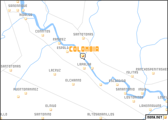
Colombia (Nuevo León, Mexico)Colombia is a town in the Nuevo León region of Mexico. An overview map of the region around Colombia is displayed below.
regional and 3d topo map of Colombia, Mexico ::
Colombia airports ::
The nearest airport is LRD - Laredo Intl, located 33.3 km south east of Colombia.
Other airports nearby include NLD - Nuevo Laredo Quetzalcoatl Intl (33.5 km south east), PDS - Piedras Negras Intl (128.5 km north west), ALI - Alice Intl (170.0 km east), LOV - Monclova Intl (189.2 km south west), Nearby towns ::
La Palma (1.9km south) //
Minera (2.6km north) //
La Morita (2.5km south east) //
Espaldillas (3.8km north west) //
Santo Tomas (4.9km north) //
El Charro (5.8km south) //
Blas María (6.5km south east) //
Ramírez (6.2km north west) //
La Cruz (6.6km south west) //
Escondida (8.6km south east) //
[all distances 'as the bird flies' and approximate] 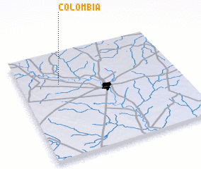 Places with similar names to Colombia, Mexico ::
Disclaimer :: Information on this page comes without warranty of any kind |
||
|
Where is Colombia? Elevation and coordinates ::
Latitude (lat): 27°42'0"N Longitude (lon): 99°45'0"W
Elevation (approx.): 148m (map arrows pan, magnifying glasses zoom) |
||
|
Visiting Colombia? Hotel/Accommodation ::
Book a hotel in Colombia Travel Guide ::
Buy a travel guide for Mexico rental cars ::
car rental offers GPS waypoint ::
download a GPX waypoint (PoI) of Colombia for your GPS receiver
|
||