|
search place name
|
||
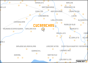
Cucarachas (Oaxaca, Mexico)Cucarachas is a town in the Oaxaca region of Mexico. An overview map of the region around Cucarachas is displayed below.
regional and 3d topo map of Cucarachas, Mexico ::
Cucarachas airports ::
The nearest airport is TGZ - Tuxtla Gutierrez Angel Albino Corzo, located 171.9 km east of Cucarachas.
Other airports nearby include MTT - Minatitlan (181.2 km north), HUX - Bahias Dehuatulco Bahias De Huatulco Intl (190.3 km south west), VSA - Villahermosa C P A Carlos Rovirosa Intl (256.9 km north east), Nearby towns ::
Dolores (4.0km east) //
San Lorenzo (5.3km west) //
Las Víboras (5.6km north) //
Las Damas (5.6km east) //
El Chorro (5.6km east) //
Los Letreros (6.5km north east) //
Las Palmas (7.2km east) //
Cerillos (7.6km north) //
Palmillas (7.3km east) //
Aguaje Pila (8.0km north east) //
Las Conchitas (8.2km south east) //
Monte Grande (9.1km north east) //
Majada de los Conchos (9.0km north west) //
Cazadero de Abajo (9.1km north west) //
San José de las Amilpas (10.3km south west) //
[all distances 'as the bird flies' and approximate] 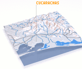 Places with similar names to Cucarachas, Mexico :: Disclaimer :: Information on this page comes without warranty of any kind |
||
|
Where is Cucarachas? Elevation and coordinates ::
Latitude (lat): 16°28'0"N Longitude (lon): 94°38'0"W
Elevation (approx.): 42m (map arrows pan, magnifying glasses zoom) |
||
|
Visiting Cucarachas? Hotel/Accommodation ::
Book a hotel in Cucarachas Travel Guide ::
Buy a travel guide for Mexico rental cars ::
car rental offers GPS waypoint ::
download a GPX waypoint (PoI) of Cucarachas for your GPS receiver
|
||