|
search place name
|
||
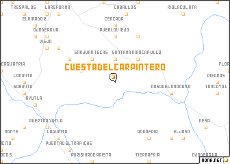
Cuesta del Carpintero (San Luis Potosí, Mexico)Cuesta del Carpintero is a town in the San Luis Potosí region of Mexico. An overview map of the region around Cuesta del Carpintero is displayed below.
regional and 3d topo map of Cuesta del Carpintero, Mexico ::
Cuesta del Carpintero airports ::
The nearest airport is TSL - Tamuin, located 95.6 km north east of Cuesta del Carpintero.
Other airports nearby include QRO - Queretaro Intercontinental (117.6 km south west), PCA - Pachuca Ingeniero Juan Guillermo Villasana (168.6 km south east), SLP - San Luis Potosi Ponciano Arriaga Intl (174.1 km north west), TAM - Tampico General Francisco Javier Mina Intl (191.6 km north east), Nearby towns ::
Mandule (3.7km north) //
Santa María Acapulco (5.1km north east) //
San Juan Tecas (5.1km north west) //
El Potrero (5.5km west) //
Carrizal Grande (7.4km north) //
Pueblo Viejo (7.4km north) //
Calabazas (8.2km north east) //
Laguna Verde (7.8km north west) //
[all distances 'as the bird flies' and approximate] 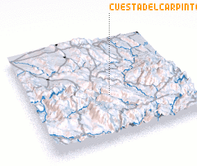 Places with similar names to Cuesta del Carpintero, Mexico :: Disclaimer :: Information on this page comes without warranty of any kind |
||
|
Where is Cuesta del Carpintero? Elevation and coordinates ::
Latitude (lat): 21°27'0"N Longitude (lon): 99°29'0"W
Elevation (approx.): 589m (map arrows pan, magnifying glasses zoom) |
||
|
Visiting Cuesta del Carpintero? Hotel/Accommodation ::
Book a hotel in Cuesta del Carpintero Travel Guide ::
Buy a travel guide for Mexico rental cars ::
car rental offers GPS waypoint ::
download a GPX waypoint (PoI) of Cuesta del Carpintero for your GPS receiver
|
||