|
search place name
|
||
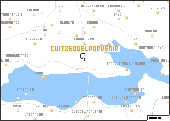
Cuitzeo del Porvenir (Michoacán de Ocampo, Mexico)Cuitzeo del Porvenir is a town in the Michoacán de Ocampo region of Mexico. An overview map of the region around Cuitzeo del Porvenir is displayed below.
regional and 3d topo map of Cuitzeo del Porvenir, Mexico ::
Cuitzeo del Porvenir airports ::
The nearest airport is MLM - Morelia General Francisco J Mujica Intl, located 19.7 km south east of Cuitzeo del Porvenir.
Other airports nearby include UPN - Uruapan Licenciado Y Gen Ignacio Lopez Rayon (113.6 km south west), BJX - Del Bajio Guanajuato Intl (117.0 km north), ZMM - Zamora (118.0 km west), QRO - Queretaro Intercontinental (122.8 km north east), Nearby towns ::
San Guillermo (2.5km south west) //
Joruco (2.5km south west) //
Chupícuaro (3.7km north) //
Rancho Seco (5.8km north) //
Cuamio (6.2km north) //
Cuaracurío (7.4km north) //
Cuamio (7.6km north) //
El Salto (8.2km north west) //
El Cerro (8.2km north west) //
Cuanamuco (10.5km north west) //
[all distances 'as the bird flies' and approximate] 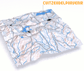 Places with similar names to Cuitzeo del Porvenir, Mexico :: Disclaimer :: Information on this page comes without warranty of any kind |
||
|
Where is Cuitzeo del Porvenir? Elevation and coordinates ::
Latitude (lat): 19°59'0"N Longitude (lon): 101°9'0"W
Elevation (approx.): 1831m (map arrows pan, magnifying glasses zoom) |
||
|
Visiting Cuitzeo del Porvenir? Hotel/Accommodation ::
Book a hotel in Cuitzeo del Porvenir Travel Guide ::
Buy a travel guide for Mexico rental cars ::
car rental offers GPS waypoint ::
download a GPX waypoint (PoI) of Cuitzeo del Porvenir for your GPS receiver
|
||