|
search place name
|
||
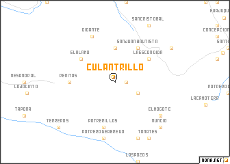
Culantrillo (Nuevo León, Mexico)Culantrillo is a town in the Nuevo León region of Mexico. An overview map of the region around Culantrillo is displayed below.
regional and 3d topo map of Culantrillo, Mexico ::
Culantrillo airports ::
The nearest airport is MTY - Monterrey General Mariano Escobedo Intl, located 50.3 km north east of Culantrillo.
Other airports nearby include NTR - Monterrey Del Norte Intl (55.8 km north), SLW - Saltillo Plan De Guadalupe Intl (64.8 km west), LOV - Monclova Intl (210.5 km north west), CVM - Ciudad Victoria General Pedro Jose Mendez Intl (230.1 km south east), Nearby towns ::
San Isidro (1.7km east) //
Laguna de Sánchez (3.8km south east) //
Panales (5.6km north) //
La Escondida (6.2km north east) //
El Álamo (6.2km north west) //
San Juan Bautista (6.5km north east) //
Peñitas (6.7km west) //
Potrerillos (7.6km south) //
Gigante (8.1km north west) //
El Mogote (8.7km south east) //
Nuncio (10.0km south east) //
[all distances 'as the bird flies' and approximate] 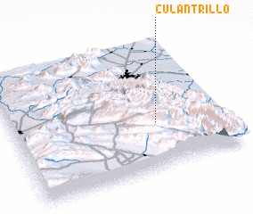 Places with similar names to Culantrillo, Mexico ::
// Kǝlǝntǝrli (AZ)
// Klein Drehle (DE)
// Culantrillo (CO)
// Culantrillo (CO)
// Culantrillo (MX)
// Culantrillo (VE)
// Glendaruel (AU)
Disclaimer :: Information on this page comes without warranty of any kind |
||
|
Where is Culantrillo? Elevation and coordinates ::
Latitude (lat): 25°22'0"N Longitude (lon): 100°19'0"W
Elevation (approx.): 1753m (map arrows pan, magnifying glasses zoom) |
||
|
Visiting Culantrillo? Hotel/Accommodation ::
Book a hotel in Culantrillo Travel Guide ::
Buy a travel guide for Mexico rental cars ::
car rental offers GPS waypoint ::
download a GPX waypoint (PoI) of Culantrillo for your GPS receiver
|
||