|
search place name
|
||
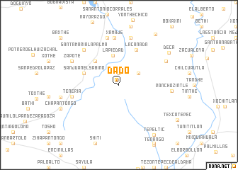
Dado (Hidalgo, Mexico)Dado is a town in the Hidalgo region of Mexico. An overview map of the region around Dado is displayed below.
regional and 3d topo map of Dado, Mexico ::
Dado airports ::
The nearest airport is PCA - Pachuca Ingeniero Juan Guillermo Villasana, located 63.4 km south east of Dado.
Other airports nearby include QRO - Queretaro Intercontinental (95.0 km west), MEX - Mexico City Licenciado Benito Juarez Intl (101.2 km south), TLC - Toluca Licenciado Adolfo Lopez Mateos Intl (111.1 km south), TXA - Tlaxcala (148.9 km south east), Nearby towns ::
Dolores (1.9km north) //
Cerro Azul (3.4km north east) //
La Piedad (4.7km north) //
San Pablo Oxtotipan (5.1km north west) //
San Juan el Sabino (5.5km west) //
La Cañada (6.1km north east) //
Xamajé (7.4km north) //
Cebolletas (7.6km north) //
Boxthó (7.6km north) //
Tenería (7.2km west) //
Santa María la Palma (7.6km north west) //
Decá (7.9km north east) //
Zapote (7.9km north west) //
Rancho Zintlé (7.9km east) //
Deca (9.0km north east) //
Tepeltic (9.4km south east) //
Cerro del Corazón (9.7km north east) //
[all distances 'as the bird flies' and approximate] 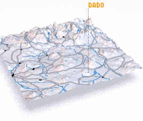 Places with similar names to Dado, Mexico ::
Disclaimer :: Information on this page comes without warranty of any kind |
||
|
Where is Dado? Elevation and coordinates ::
Latitude (lat): 20°19'0"N Longitude (lon): 99°20'0"W
Elevation (approx.): 2121m (map arrows pan, magnifying glasses zoom) |
||
|
Visiting Dado? Hotel/Accommodation ::
Book a hotel in Dado Travel Guide ::
Buy a travel guide for Mexico rental cars ::
car rental offers GPS waypoint ::
download a GPX waypoint (PoI) of Dado for your GPS receiver
|
||