|
search place name
|
||
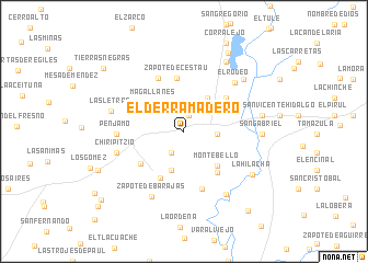
El Derramadero (Guanajuato, Mexico)El Derramadero is a town in the Guanajuato region of Mexico. An overview map of the region around El Derramadero is displayed below.
regional and 3d topo map of El Derramadero, Mexico ::
El Derramadero airports ::
The nearest airport is BJX - Del Bajio Guanajuato Intl, located 64.9 km north of El Derramadero.
Other airports nearby include ZMM - Zamora (76.5 km south west), MLM - Morelia General Francisco J Mujica Intl (93.7 km south east), UPN - Uruapan Licenciado Y Gen Ignacio Lopez Rayon (121.3 km south), AGU - Aguascalientes Jesus Teran Intl (155.8 km north west), Nearby towns ::
La Tepuza (1.7km north) //
La Labor (2.5km south west) //
La Purísima (3.3km east) //
Haciendita (4.2km south) //
La Trinidad (4.2km south) //
Corral de Ramas (4.1km north east) //
Magallanes (4.1km north west) //
Montebello (4.8km south east) //
Estancia Pénjamo (5.2km south west) //
San Pedro (5.2km south east) //
Zapote de Cestaú (5.4km north) //
San Miguel de Villaseñor (5.3km south west) //
Carrizo (5.3km north east) //
La Lagunita (5.9km north west) //
La Granjena (6.1km south) //
Pénjamo (6.4km west) //
El Rodeo (6.9km north east) //
Chiripitzio (6.8km west) //
Zapote de Barajas (7.4km south west) //
Las Letras (7.2km west) //
Capilla de Márquez (7.6km south east) //
San Gabriel (7.5km east) //
La Ordeña de Parajes (7.8km north east) //
San Ignacio (7.6km east) //
La Hilacha (7.9km south east) //
Agua Tibia de Ayala (8.2km north east) //
Corralejo Hidalgo (9.1km north east) //
La Tuza (9.1km south west) //
Tierras Negras (10.0km north west) //
[all distances 'as the bird flies' and approximate]  Places with similar names to El Derramadero, Mexico ::
// El Dormidero (PA)
// El Derumbadero (CU)
// El Dormidero (CO)
// El Derramadero (MX)
// El Derramadero (MX)
// El Derramadero (MX)
// El Derramadero (MX)
// El Derramadero (MX)
// El Derrumbadero (MX)
// El Dormidero (MX)
Disclaimer :: Information on this page comes without warranty of any kind |
||
|
Where is El Derramadero? Elevation and coordinates ::
Latitude (lat): 20°26'9"N Longitude (lon): 101°40'18"W
Elevation (approx.): 1706m (map arrows pan, magnifying glasses zoom) |
||
|
Visiting El Derramadero? Hotel/Accommodation ::
Book a hotel in El Derramadero Travel Guide ::
Buy a travel guide for Mexico rental cars ::
car rental offers GPS waypoint ::
download a GPX waypoint (PoI) of El Derramadero for your GPS receiver
|
||