|
search place name
|
||
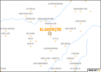
El Durazno (Zacatecas, Mexico)El Durazno is a town in the Zacatecas region of Mexico. An overview map of the region around El Durazno is displayed below.
regional and 3d topo map of El Durazno, Mexico ::
El Durazno airports ::
The nearest airport is ZCL - Zacatecas General Leobardo C Ruiz Intl, located 94.4 km north east of El Durazno.
Other airports nearby include AGU - Aguascalientes Jesus Teran Intl (150.4 km south east), TPQ - Tepic (183.2 km south west), DGO - Durango Intl (208.4 km north west), GDL - Guadalajara Don Miguel Hidalgo Y Costilla Intl (219.9 km south), Nearby towns ::
San Ramón (0.0km north) //
Vitla (2.5km south east) //
El Portillo (2.5km north east) //
Paso del Río (3.7km north) //
Laguna Grande (5.6km south) //
El Salto (5.5km west) //
Rancho de Arriba (5.8km north) //
San Jorge (6.3km south east) //
Pastoría (6.5km north west) //
Soledad (6.8km west) //
Mastranto (7.1km east) //
Muza (7.1km west) //
Masita (7.8km south west) //
San Pedro (8.8km north west) //
[all distances 'as the bird flies' and approximate]  Places with similar names to El Durazno, Mexico ::
// El Durazno (ES)
// El Durazno (CL)
// El Durazno (CL)
// El Durazno (CO)
// El Durazno (CO)
// El Durazno (SV)
// El Durazno (GT)
// El Durazno (GT)
// El Durazno (GT)
// El Durazno (GT)
Disclaimer :: Information on this page comes without warranty of any kind |
||
|
Where is El Durazno? Elevation and coordinates ::
Latitude (lat): 22°30'0"N Longitude (lon): 103°30'0"W
Elevation (approx.): 2210m (map arrows pan, magnifying glasses zoom) |
||
|
Visiting El Durazno? Hotel/Accommodation ::
Book a hotel in El Durazno Travel Guide ::
Buy a travel guide for Mexico rental cars ::
car rental offers GPS waypoint ::
download a GPX waypoint (PoI) of El Durazno for your GPS receiver
|
||