|
search place name
|
||
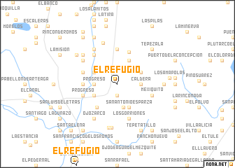
El Refugio (Aguascalientes, Mexico)El Refugio is a town in the Aguascalientes region of Mexico. An overview map of the region around El Refugio is displayed below.
regional and 3d topo map of El Refugio, Mexico ::
El Refugio airports ::
The nearest airport is AGU - Aguascalientes Jesus Teran Intl, located 52.1 km south of El Refugio.
Other airports nearby include ZCL - Zacatecas General Leobardo C Ruiz Intl (94.2 km north west), SLP - San Luis Potosi Ponciano Arriaga Intl (132.9 km east), BJX - Del Bajio Guanajuato Intl (150.6 km south east), GDL - Guadalajara Don Miguel Hidalgo Y Costilla Intl (214.6 km south west), Nearby towns ::
El Fénix (1.9km south) //
La Tuza (3.4km west) //
Progreso (3.4km west) //
Caldera (3.4km east) //
Adolfo López Mateos (3.8km south) //
Casa Blanca (3.9km north west) //
El Moro (3.9km north west) //
Carboneras (3.9km north west) //
Pabellón de Arteaga (3.9km south west) //
Arroyo Hondo (4.1km north east) //
Colonia Obregón (3.9km north east) //
San Antonio Esparza (4.1km south east) //
Javier Ambriz (4.8km south west) //
Los Hornos (5.4km north) //
Corrales de Engorda (5.1km west) //
San Pedro del Cobre (5.6km north) //
Dieciocho de Marzo (5.5km west) //
Progreso (5.5km west) //
Los Gorriones (5.8km south) //
Mexiquito (5.5km east) //
El águila (5.8km north west) //
El Gigante (5.8km north west) //
Los Ángeles (6.3km north west) //
Ojo Zarco (6.5km south west) //
San Antonio (6.5km north west) //
La Victoria (6.8km north) //
Los Martínez (7.0km south) //
Las Barranquitas (7.1km south) //
El Zorrillo (6.9km north west) //
[all distances 'as the bird flies' and approximate] 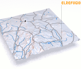 Places with similar names to El Refugio, Mexico ::
// El Refugio (US)
// El Refugio (US)
// El Refugio (SV)
// El Refugio (SV)
// El Refugio (SV)
// El Refugio (GT)
// El Refugio (GT)
// El Refugio (GT)
// El Refugio (GT)
// El Refugio (MX)
Disclaimer :: Information on this page comes without warranty of any kind |
||
|
Where is El Refugio? Elevation and coordinates ::
Latitude (lat): 22°10'0"N Longitude (lon): 102°13'0"W
Elevation (approx.): 1962m (map arrows pan, magnifying glasses zoom) |
||
|
Visiting El Refugio? Hotel/Accommodation ::
Book a hotel in El Refugio Travel Guide ::
Buy a travel guide for Mexico rental cars ::
car rental offers GPS waypoint ::
download a GPX waypoint (PoI) of El Refugio for your GPS receiver
|
||