|
search place name
|
||
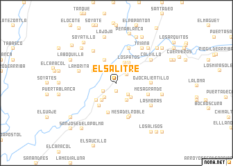
El Salitre (Aguascalientes, Mexico)El Salitre is a town in the Aguascalientes region of Mexico. An overview map of the region around El Salitre is displayed below.
regional and 3d topo map of El Salitre, Mexico ::
El Salitre airports ::
The nearest airport is AGU - Aguascalientes Jesus Teran Intl, located 48.0 km east of El Salitre.
Other airports nearby include ZCL - Zacatecas General Leobardo C Ruiz Intl (119.9 km north), GDL - Guadalajara Don Miguel Hidalgo Y Costilla Intl (154.1 km south), BJX - Del Bajio Guanajuato Intl (161.5 km south east), SLP - San Luis Potosi Ponciano Arriaga Intl (195.6 km east), Nearby towns ::
La Tinaja (1.4km south) //
Michoacanejo (1.9km north) //
Tepalcate (2.0km north) //
Crucero Las Pilas (2.1km north east) //
La Turicata (2.4km south west) //
Las Praderas (2.5km south east) //
Salitrillo (2.9km south west) //
El Gallo (3.2km south east) //
La Calera (3.2km south east) //
Barranca de Portales (3.5km north) //
Ojo de Agua (3.5km south west) //
Los Patos (3.7km north east) //
Cerro Blanco (3.9km north west) //
Barranca de Ánimas (4.1km north west) //
La Media Luna (4.1km south west) //
La Rinconada (4.5km south west) //
Jaltiche de Arriba (5.0km south) //
Mesa Grande (5.1km east) //
Ojocalientillo (5.2km east) //
Barranca del Roble (5.8km south) //
Mesa del Roble (5.8km south) //
El Rodeo (5.9km north) //
La Morita (5.9km west) //
El Frentón (6.1km north west) //
Calvillo (6.4km north east) //
Las Moras (6.4km south east) //
Triana (6.8km north east) //
Los Cerritos (7.3km north east) //
La Joja (7.6km north) //
[all distances 'as the bird flies' and approximate]  Places with similar names to El Salitre, Mexico ::
// El Salidero (PA)
// El Salitre (PA)
// El Salitre (PA)
// El Salitre (PA)
// El Salitre (PA)
// El Salitre (PA)
// El Salitre (PA)
// El Salitre (SV)
// El Salitre (SV)
// El Salitre (SV)
Disclaimer :: Information on this page comes without warranty of any kind |
||
|
Where is El Salitre? Elevation and coordinates ::
Latitude (lat): 21°49'0"N Longitude (lon): 102°46'0"W
Elevation (approx.): 1612m (map arrows pan, magnifying glasses zoom) |
||
|
Visiting El Salitre? Hotel/Accommodation ::
Book a hotel in El Salitre Travel Guide ::
Buy a travel guide for Mexico rental cars ::
car rental offers GPS waypoint ::
download a GPX waypoint (PoI) of El Salitre for your GPS receiver
|
||