|
search place name
|
||
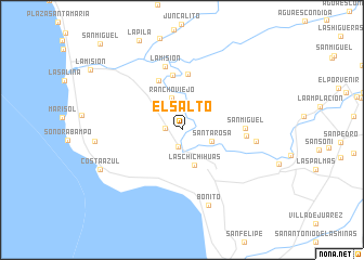
El Salto (Baja California, Mexico)El Salto is a town in the Baja California region of Mexico. An overview map of the region around El Salto is displayed below.
regional and 3d topo map of El Salto, Mexico ::
El Salto airports ::
The nearest airport is ESE - Ensenada, located 31.3 km south east of El Salto.
Other airports nearby include TIJ - Tijuana General Abelardo L Rodriguez Intl (58.9 km north), NZY - San Diego North Island Nas (84.4 km north west), SAN - San Diego Intl (86.6 km north west), NKX - Miramar Mcas (98.5 km north), Nearby towns ::
Los Hornos (1.5km west) //
Santa Rosa (1.8km south) //
Santa Rosa (2.8km south east) //
Rancho Viejo (3.4km north) //
Las Chichihuas (3.8km south) //
Rancho Viejo (5.5km north) //
La Misión (5.6km north) //
Rancho Viejo (5.8km north) //
San Miguel (5.6km east) //
Ojeda (5.7km east) //
La Misión (6.7km north) //
Cubillas (6.6km east) //
Bonito (8.1km south) //
Costa Azul (8.2km south west) //
San Miguel (11.4km north west) //
[all distances 'as the bird flies' and approximate] 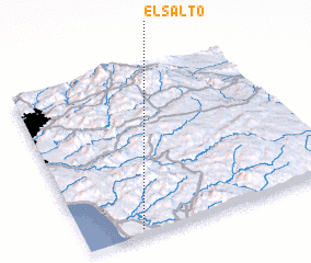 Places with similar names to El Salto, Mexico ::
Disclaimer :: Information on this page comes without warranty of any kind |
||
|
Where is El Salto? Elevation and coordinates ::
Latitude (lat): 32°2'13"N Longitude (lon): 116°46'27"W
Elevation (approx.): 259m (map arrows pan, magnifying glasses zoom) |
||
|
Visiting El Salto? Hotel/Accommodation ::
Book a hotel in El Salto Travel Guide ::
Buy a travel guide for Mexico rental cars ::
car rental offers GPS waypoint ::
download a GPX waypoint (PoI) of El Salto for your GPS receiver
|
||