|
search place name
|
||
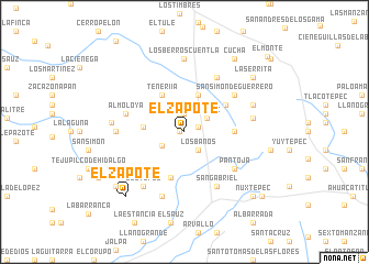
El Zapote (México, Mexico)El Zapote is a town in the México region of Mexico. An overview map of the region around El Zapote is displayed below.
regional and 3d topo map of El Zapote, Mexico ::
El Zapote airports ::
The nearest airport is TLC - Toluca Licenciado Adolfo Lopez Mateos Intl, located 68.7 km north east of El Zapote.
Other airports nearby include CVJ - Cuernavaca General Mariano Matamoros (85.1 km east), MEX - Mexico City Licenciado Benito Juarez Intl (118.1 km north east), MLM - Morelia General Francisco J Mujica Intl (143.3 km north west), PBC - Puebla Hermanos Serdan Intl (179.7 km east), Nearby towns ::
Cuentla (0.4km west) //
El Salitre (1.5km north) //
Guardarraya (1.4km east) //
Llano Grande (1.9km north) //
Los Baños (2.3km south east) //
Titipac (2.6km north east) //
Jocoyoles (2.6km south west) //
San Gabriel Cuentla (3.9km north) //
La Cumbre (4.0km west) //
Teneriía (4.3km north west) //
Aquiagua (4.8km south) //
Peña Redonda (4.8km north east) //
El Maguey (4.8km east) //
Mazatepec (5.4km south west) //
Pantoja (6.1km south east) //
San Simón de Guerrero (6.1km north east) //
Almoloya (6.0km west) //
Buenavista (6.3km north east) //
San Gabriel (6.4km south east) //
La Labor de Zaragoza (6.8km south) //
Ocotepec (6.8km south west) //
Agua Bendita (6.6km west) //
Rincón del Carmen (6.8km south west) //
Ojo de Agua (6.7km east) //
Los Berros Cuentla (7.4km north) //
Ojo de Agua (7.1km west) //
Rancho Viejo (7.1km north east) //
El Zapote (8.6km south west) //
Zacatepec (8.6km south west) //
[all distances 'as the bird flies' and approximate] 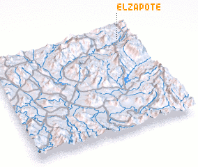 Places with similar names to El Zapote, Mexico ::
Disclaimer :: Information on this page comes without warranty of any kind |
||
|
Where is El Zapote? Elevation and coordinates ::
Latitude (lat): 18°56'0"N Longitude (lon): 100°3'45"W
Elevation (approx.): 1655m (map arrows pan, magnifying glasses zoom) |
||
|
Visiting El Zapote? Hotel/Accommodation ::
Book a hotel in El Zapote Travel Guide ::
Buy a travel guide for Mexico rental cars ::
car rental offers GPS waypoint ::
download a GPX waypoint (PoI) of El Zapote for your GPS receiver
|
||