|
search place name
|
||
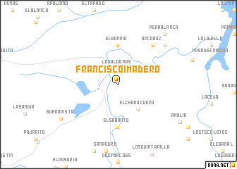
Francisco I. Madero (Nuevo León, Mexico)Francisco I. Madero is a town in the Nuevo León region of Mexico. An overview map of the region around Francisco I. Madero is displayed below.
regional and 3d topo map of Francisco I. Madero, Mexico ::
Francisco I. Madero airports ::
The nearest airport is REX - Reynosa General Lucio Blanco Intl, located 95.5 km east of Francisco I. Madero.
Other airports nearby include MFE - Mcallen Mc Allen Miller Intl (95.8 km east), MTY - Monterrey General Mariano Escobedo Intl (96.7 km west), NTR - Monterrey Del Norte Intl (107.2 km west), HRL - Harlingen Valley Intl (154.4 km east), Nearby towns ::
Los Aldamas (2.5km north) //
El Tecomate (4.0km north east) //
El Chamacuero (4.9km south east) //
El Barrio (6.2km north) //
El Sabinito (6.8km south) //
Arcabuz (7.9km north east) //
Marroquines (9.0km north east) //
Peña Blanca (10.3km north east) //
[all distances 'as the bird flies' and approximate]  Places with similar names to Francisco I. Madero, Mexico ::
// Francisco I. Madero (MX)
// Francisco I. Madero (MX)
// Francisco I. Madero (MX)
// Francisco I. Madero (MX)
// Francisco I. Madero (MX)
// Francisco I. Madero (MX)
// Francisco I. Madero (MX)
// Francisco I. Madero (MX)
// Francisco I. Madero (MX)
// Francisco I. Madero (MX)
Disclaimer :: Information on this page comes without warranty of any kind |
||
|
Where is Francisco I. Madero? Elevation and coordinates ::
Latitude (lat): 26°1'40"N Longitude (lon): 99°10'55"W
Elevation (approx.): 105m (map arrows pan, magnifying glasses zoom) |
||
|
Visiting Francisco I. Madero? Hotel/Accommodation ::
Book a hotel in Francisco I. Madero Travel Guide ::
Buy a travel guide for Mexico rental cars ::
car rental offers GPS waypoint ::
download a GPX waypoint (PoI) of Francisco I. Madero for your GPS receiver
|
||