|
search place name
|
||
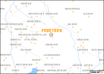
Frontera (Oaxaca, Mexico)Frontera is a town in the Oaxaca region of Mexico. An overview map of the region around Frontera is displayed below.
regional and 3d topo map of Frontera, Mexico ::
Frontera airports ::
The nearest airport is TGZ - Tuxtla Gutierrez Angel Albino Corzo, located 114.4 km east of Frontera.
Other airports nearby include MTT - Minatitlan (205.2 km north), VSA - Villahermosa C P A Carlos Rovirosa Intl (228.6 km north east), TAP - Tapachula Intl (248.0 km south east), Nearby towns ::
Las Marías (0.0km north) //
El Espinal (1.9km north) //
Guadalupe (3.7km south) //
Ajalá (4.3km north east) //
Carmen (5.6km west) //
Santa Rita (6.4km west) //
San José de los Portillos (6.7km west) //
Guadalupe (7.4km north) //
Llano Redondo (7.4km south) //
Ixtaltepec (7.4km west) //
Guadalupe (7.6km south) //
Casa Blanca (7.8km north west) //
Independencia (8.0km north west) //
Dolores (8.0km north east) //
San Francisco (9.1km north west) //
Minas (10.3km north west) //
[all distances 'as the bird flies' and approximate] 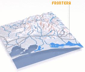 Places with similar names to Frontera, Mexico ::
Disclaimer :: Information on this page comes without warranty of any kind |
||
|
Where is Frontera? Elevation and coordinates ::
Latitude (lat): 16°19'0"N Longitude (lon): 94°4'0"W
Elevation (approx.): 179m (map arrows pan, magnifying glasses zoom) |
||
|
Visiting Frontera? Hotel/Accommodation ::
Book a hotel in Frontera Travel Guide ::
Buy a travel guide for Mexico rental cars ::
car rental offers GPS waypoint ::
download a GPX waypoint (PoI) of Frontera for your GPS receiver
|
||