|
search place name
|
||
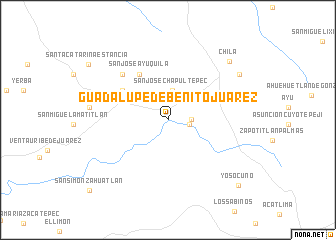
Guadalupe de Benito Juárez (Oaxaca, Mexico)Guadalupe de Benito Juárez is a town in the Oaxaca region of Mexico. An overview map of the region around Guadalupe de Benito Juárez is displayed below.
regional and 3d topo map of Guadalupe de Benito Juárez, Mexico ::
Guadalupe de Benito Juárez airports ::
The nearest airport is TCN - Tehuacan, located 83.0 km north east of Guadalupe de Benito Juárez.
Other airports nearby include PBC - Puebla Hermanos Serdan Intl (145.0 km north), OAX - Oaxaca Xoxocotlan Intl (162.8 km south east), CVJ - Cuernavaca General Mariano Matamoros (174.0 km north west), TXA - Tlaxcala (181.0 km north), Nearby towns ::
Concepción (2.3km east) //
San José Chapultepec (2.5km east) //
San José Chapultepec (3.3km north) //
Santiago Ayuquililla (5.8km north west) //
San José Ayuquila (5.9km north west) //
San José Estancia Grande (7.0km north west) //
Zapote (8.4km west) //
Chirimoya (9.1km north east) //
Chila (9.3km north east) //
Yosocuno (10.5km south east) //
Santa Catarina Estancia (10.4km north west) //
San Simón Zahuatlán (11.5km south west) //
[all distances 'as the bird flies' and approximate]  Places with similar names to Guadalupe de Benito Juárez, Mexico :: Disclaimer :: Information on this page comes without warranty of any kind |
||
|
Where is Guadalupe de Benito Juárez? Elevation and coordinates ::
Latitude (lat): 17°55'15"N Longitude (lon): 97°55'17"W
Elevation (approx.): 1631m (map arrows pan, magnifying glasses zoom) |
||
|
Visiting Guadalupe de Benito Juárez? Hotel/Accommodation ::
Book a hotel in Guadalupe de Benito Juárez Travel Guide ::
Buy a travel guide for Mexico rental cars ::
car rental offers GPS waypoint ::
download a GPX waypoint (PoI) of Guadalupe de Benito Juárez for your GPS receiver
|
||