|
search place name
|
||
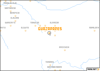
Guazapares (Chihuahua, Mexico)Guazapares is a town in the Chihuahua region of Mexico. An overview map of the region around Guazapares is displayed below.
regional and 3d topo map of Guazapares, Mexico ::
Guazapares airports ::
The nearest airport is CEN - Ciudad Obregon Intl, located 156.6 km west of Guazapares.
Other airports nearby include LMM - Los Mochis Valle Del Fuerte Intl (203.9 km south west), Nearby towns ::
Mineral (1.6km east) //
San Isidro (2.5km north west) //
San José (2.5km north east) //
El Rincón (4.1km north east) //
Sangre de Cristo (4.1km north west) //
Batosegachic (5.0km north west) //
Tohuiles (6.2km north west) //
Ericicuchi (7.4km south east) //
[all distances 'as the bird flies' and approximate] 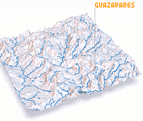 Places with similar names to Guazapares, Mexico ::
// Caspars (US)
// Casa Parisi (IT)
// Kasparus (PL)
// Casa Aparicio (ES)
// Guzparras (ES)
// Gašparci (HR)
Disclaimer :: Information on this page comes without warranty of any kind |
||
|
Where is Guazapares? Elevation and coordinates ::
Latitude (lat): 27°22'0"N Longitude (lon): 108°15'0"W
Elevation (approx.): 1897m (map arrows pan, magnifying glasses zoom) |
||
|
Visiting Guazapares? Hotel/Accommodation ::
Book a hotel in Guazapares Travel Guide ::
Buy a travel guide for Mexico rental cars ::
car rental offers GPS waypoint ::
download a GPX waypoint (PoI) of Guazapares for your GPS receiver
|
||