|
search place name
|
||
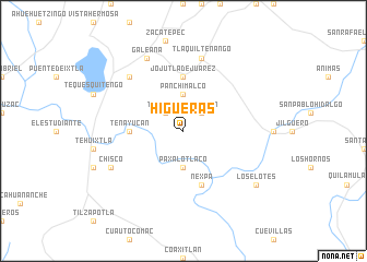
Higueras (Morelos, Mexico)Higueras is a town in the Morelos region of Mexico. An overview map of the region around Higueras is displayed below.
regional and 3d topo map of Higueras, Mexico ::
Higueras airports ::
The nearest airport is CVJ - Cuernavaca General Mariano Matamoros, located 30.8 km north of Higueras.
Other airports nearby include TLC - Toluca Licenciado Adolfo Lopez Mateos Intl (94.3 km north west), MEX - Mexico City Licenciado Benito Juarez Intl (97.0 km north), PBC - Puebla Hermanos Serdan Intl (107.7 km north east), TXA - Tlaxcala (151.2 km north east), Nearby towns ::
Higuerón (2.6km north east) //
Tlatenchi (2.6km north west) //
Panchimalco (3.7km north) //
Paxalotlaco (3.7km south) //
Tenayucan (5.3km west) //
Jojutla de Juárez (5.6km north) //
Nexpa (5.8km south) //
Tlaquiltenango (7.6km north) //
El Jicarero (7.7km north west) //
Galeana (8.2km north west) //
Chisco (7.9km south west) //
Los Elotes (9.0km south east) //
[all distances 'as the bird flies' and approximate] 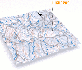 Places with similar names to Higueras, Mexico ::
Disclaimer :: Information on this page comes without warranty of any kind |
||
|
Where is Higueras? Elevation and coordinates ::
Latitude (lat): 18°34'0"N Longitude (lon): 99°11'0"W
Elevation (approx.): 914m (map arrows pan, magnifying glasses zoom) |
||
|
Visiting Higueras? Hotel/Accommodation ::
Book a hotel in Higueras Travel Guide ::
Buy a travel guide for Mexico rental cars ::
car rental offers GPS waypoint ::
download a GPX waypoint (PoI) of Higueras for your GPS receiver
|
||