|
search place name
|
||
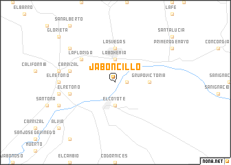
Jaboncillo (Coahuila de Zaragoza, Mexico)Jaboncillo is a town in the Coahuila de Zaragoza region of Mexico. An overview map of the region around Jaboncillo is displayed below.
regional and 3d topo map of Jaboncillo, Mexico ::
Jaboncillo airports ::
The nearest airport is TRC - Torreon Intl, located 23.3 km south west of Jaboncillo.
Other airports nearby include DGO - Durango Intl (219.1 km south west), LOV - Monclova Intl (224.7 km north east), Nearby towns ::
El Carmen (1.7km east) //
El Coyote (3.7km south) //
La Bohemia (3.7km north) //
Las Vegas (5.6km north) //
Grupo Victoria (5.0km east) //
La Florida (6.2km north west) //
El Retoño (6.9km west) //
Carrizal (6.9km west) //
El Recuerdo de Francisco Villa (8.7km north west) //
[all distances 'as the bird flies' and approximate] 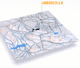 Places with similar names to Jaboncillo, Mexico ::
// Jaboncillo (CR)
// Jaboncillo (EC)
// Jaboncillo (EC)
// Jaboncillo (EC)
// Jaboncillo (MX)
// Jaboncillo (MX)
// Jaboncillo (PE)
// Jaboncillo (PE)
Disclaimer :: Information on this page comes without warranty of any kind |
||
|
Where is Jaboncillo? Elevation and coordinates ::
Latitude (lat): 25°44'0"N Longitude (lon): 103°16'0"W
Elevation (approx.): 1113m (map arrows pan, magnifying glasses zoom) |
||
|
Visiting Jaboncillo? Hotel/Accommodation ::
Book a hotel in Jaboncillo Travel Guide ::
Buy a travel guide for Mexico rental cars ::
car rental offers GPS waypoint ::
download a GPX waypoint (PoI) of Jaboncillo for your GPS receiver
|
||