|
search place name
|
||
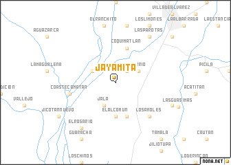
Jayamita (Colima, Mexico)Jayamita is a town in the Colima region of Mexico. An overview map of the region around Jayamita is displayed below.
regional and 3d topo map of Jayamita, Mexico ::
Jayamita airports ::
The nearest airport is CLQ - Colima, located 28.8 km north east of Jayamita.
Other airports nearby include ZLO - Manzanillo Playa De Oro Intl (78.1 km west), GDL - Guadalajara Don Miguel Hidalgo Y Costilla Intl (160.8 km north), UPN - Uruapan Licenciado Y Gen Ignacio Lopez Rayon (188.8 km east), ZMM - Zamora (189.6 km north east), Nearby towns ::
Rincón del Barrio (2.5km north east) //
Jala (4.1km south west) //
El Sarano (4.0km north west) //
Los Mezcales (4.0km north east) //
El Alcomún (5.6km south) //
Agua Salada (5.8km south) //
Coquimatlán (5.8km north) //
Coastecomatán (7.2km west) //
Los Amoles (7.6km south east) //
El Rosario (9.1km south west) //
Las Parotas (9.1km north east) //
[all distances 'as the bird flies' and approximate] 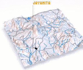
Disclaimer :: Information on this page comes without warranty of any kind |
||
|
Where is Jayamita? Elevation and coordinates ::
Latitude (lat): 19°9'0"N Longitude (lon): 103°49'0"W
Elevation (approx.): 400m (map arrows pan, magnifying glasses zoom) |
||
|
Visiting Jayamita? Hotel/Accommodation ::
Book a hotel in Jayamita Travel Guide ::
Buy a travel guide for Mexico rental cars ::
car rental offers GPS waypoint ::
download a GPX waypoint (PoI) of Jayamita for your GPS receiver
|
||