|
search place name
|
||
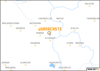
Juanacaste (Nayarit, Mexico)Juanacaste is a town in the Nayarit region of Mexico. An overview map of the region around Juanacaste is displayed below.
regional and 3d topo map of Juanacaste, Mexico ::
Juanacaste airports ::
The nearest airport is TPQ - Tepic, located 29.1 km west of Juanacaste.
Other airports nearby include PVR - Puerto Vallarta Licenciado Gustavo Diaz Ordaz Intl (112.6 km south west), GDL - Guadalajara Don Miguel Hidalgo Y Costilla Intl (167.3 km south east), ZCL - Zacatecas General Leobardo C Ruiz Intl (250.3 km north east), MZT - Mazatlan General Rafael Buelna Intl (256.7 km north west), Nearby towns ::
El Ciruelo (1.9km south) //
Mirador (3.4km west) //
Los Zorrillos (5.8km north) //
Buckingham (6.4km north west) //
Mojarras (6.4km south west) //
Bueyes (6.5km north east) //
Ixtapa (7.8km south east) //
[all distances 'as the bird flies' and approximate] 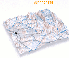 Places with similar names to Juanacaste, Mexico ::
// Jaanikeste (EE)
// Geangoeşti (RO)
// Juanacaste (MX)
// Juan Acosta (CU)
// Gingst (DE)
// Gingsta (SE)
Disclaimer :: Information on this page comes without warranty of any kind |
||
|
Where is Juanacaste? Elevation and coordinates ::
Latitude (lat): 21°28'0"N Longitude (lon): 104°34'0"W
Elevation (approx.): 512m (map arrows pan, magnifying glasses zoom) |
||
|
Visiting Juanacaste? Hotel/Accommodation ::
Book a hotel in Juanacaste Travel Guide ::
Buy a travel guide for Mexico rental cars ::
car rental offers GPS waypoint ::
download a GPX waypoint (PoI) of Juanacaste for your GPS receiver
|
||