|
search place name
|
||
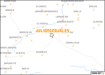
Julián Grajales (Chiapas, Mexico)Julián Grajales is a town in the Chiapas region of Mexico. An overview map of the region around Julián Grajales is displayed below.
regional and 3d topo map of Julián Grajales, Mexico ::
Julián Grajales airports ::
The nearest airport is TGZ - Tuxtla Gutierrez Angel Albino Corzo, located 75.1 km east of Julián Grajales.
Other airports nearby include VSA - Villahermosa C P A Carlos Rovirosa Intl (198.3 km north east), MTT - Minatitlan (207.2 km north west), TAP - Tapachula Intl (231.1 km south east), Nearby towns ::
San Clemente (0.8km north) //
Plan de Ayala (4.7km north east) //
El Triunfo (5.1km north west) //
San Dionisio (5.2km east) //
San Vicente (5.8km north east) //
Union Agrarista (6.4km north east) //
La Asunción (7.2km north east) //
Michoacán (7.3km south west) //
Independencia (7.1km north west) //
Baja California (7.3km west) //
Corral Viejo (7.6km south east) //
José María Pino Suárez (8.4km north) //
[all distances 'as the bird flies' and approximate] 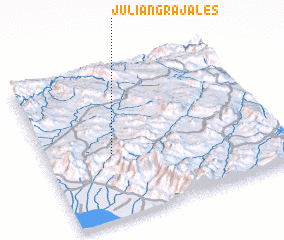 Places with similar names to Julián Grajales, Mexico ::
// Julian Grajales (MX)
Disclaimer :: Information on this page comes without warranty of any kind |
||
|
Where is Julián Grajales? Elevation and coordinates ::
Latitude (lat): 16°25'35"N Longitude (lon): 93°42'55"W
Elevation (approx.): 615m (map arrows pan, magnifying glasses zoom) |
||
|
Visiting Julián Grajales? Hotel/Accommodation ::
Book a hotel in Julián Grajales Travel Guide ::
Buy a travel guide for Mexico rental cars ::
car rental offers GPS waypoint ::
download a GPX waypoint (PoI) of Julián Grajales for your GPS receiver
|
||