|
search place name
|
||
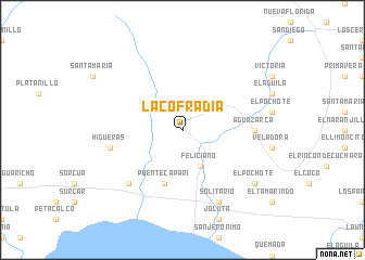
La Cofradía (Guerrero, Mexico)La Cofradía is a town in the Guerrero region of Mexico. An overview map of the region around La Cofradía is displayed below.
regional and 3d topo map of La Cofradía, Mexico ::
La Cofradía airports ::
The nearest airport is LZC - Lazard Cardenas Lazaro Cardenas, located 26.1 km west of La Cofradía.
Other airports nearby include ZIH - Ixtapa Zihuatanejo Intl (75.6 km south east), UPN - Uruapan Licenciado Y Gen Ignacio Lopez Rayon (147.3 km north), CLQ - Colima (215.0 km north west), ZMM - Zamora (221.1 km north), Nearby towns ::
Feliciano (4.1km south east) //
Coyuquilla (5.8km south) //
Puente Capari (5.8km south) //
Agua Zarca (7.0km east) //
Higueras (7.3km west) //
La Salada (7.7km south west) //
Solitario (8.2km south east) //
El Pochote (9.0km south east) //
[all distances 'as the bird flies' and approximate] 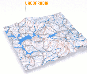 Places with similar names to La Cofradía, Mexico ::
// Lockeford (US)
// Lake Ford (US)
// Lago Verde (CL)
// Logovardi (MK)
// La Cofradía (MX)
// La Cofradía (MX)
// La Cofradía (MX)
// La Cofradía (MX)
// La Cofradía (MX)
// La Cofradía (MX)
Disclaimer :: Information on this page comes without warranty of any kind |
||
|
Where is La Cofradía? Elevation and coordinates ::
Latitude (lat): 18°4'0"N Longitude (lon): 101°59'0"W
Elevation (approx.): 127m (map arrows pan, magnifying glasses zoom) |
||
|
Visiting La Cofradía? Hotel/Accommodation ::
Book a hotel in La Cofradía Travel Guide ::
Buy a travel guide for Mexico rental cars ::
car rental offers GPS waypoint ::
download a GPX waypoint (PoI) of La Cofradía for your GPS receiver
|
||