|
search place name
|
||
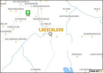
La Escalera (Chiapas, Mexico)La Escalera is a town in the Chiapas region of Mexico. An overview map of the region around La Escalera is displayed below.
regional and 3d topo map of La Escalera, Mexico ::
La Escalera airports ::
The nearest airport is TGZ - Tuxtla Gutierrez Angel Albino Corzo, located 11.9 km north west of La Escalera.
Other airports nearby include VSA - Villahermosa C P A Carlos Rovirosa Intl (168.1 km north), TAP - Tapachula Intl (197.0 km south), MTT - Minatitlan (249.4 km north west), Nearby towns ::
Rancho Nuevo (1.8km east) //
La Providencia (1.8km east) //
Rancho Nuevo (2.6km north west) //
Julian Grajales (2.6km west) //
El Altejar (4.0km north west) //
El Tablón (4.1km north west) //
Nicolás Bravo (5.2km north west) //
Barranca Honda (6.6km north west) //
Veinte de Noviembre (9.0km north east) //
Francisco Sarabia (9.1km north west) //
[all distances 'as the bird flies' and approximate] 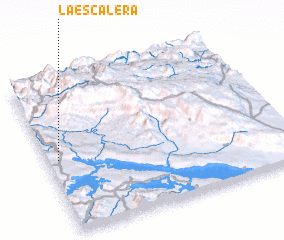 Places with similar names to La Escalera, Mexico ::
// La Escalera (CL)
// La Escalera (EC)
// La Escalera (MX)
// La Escalera (MX)
// Los Aguilar (MX)
// La Escalera (HN)
// La Escalería (HN)
// Los Aguilera (HN)
// La Escalera (VE)
// La Escalera (VE)
Disclaimer :: Information on this page comes without warranty of any kind |
||
|
Where is La Escalera? Elevation and coordinates ::
Latitude (lat): 16°29'0"N Longitude (lon): 92°57'0"W
Elevation (approx.): 547m (map arrows pan, magnifying glasses zoom) |
||
|
Visiting La Escalera? Hotel/Accommodation ::
Book a hotel in La Escalera Travel Guide ::
Buy a travel guide for Mexico rental cars ::
car rental offers GPS waypoint ::
download a GPX waypoint (PoI) of La Escalera for your GPS receiver
|
||