|
search place name
|
||
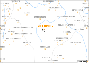
La Florida (Hidalgo, Mexico)La Florida is a town in the Hidalgo region of Mexico. An overview map of the region around La Florida is displayed below.
regional and 3d topo map of La Florida, Mexico ::
La Florida airports ::
The nearest airport is PCA - Pachuca Ingeniero Juan Guillermo Villasana, located 56.4 km south of La Florida.
Other airports nearby include MEX - Mexico City Licenciado Benito Juarez Intl (123.6 km south), QRO - Queretaro Intercontinental (125.6 km west), TXA - Tlaxcala (140.5 km south east), TLC - Toluca Licenciado Adolfo Lopez Mateos Intl (147.5 km south west), Nearby towns ::
Emilio Hernández (0.6km north) //
San Cristóbal (5.5km north) //
Mantha (7.0km south east) //
Nopalillos (7.4km south) //
Lomas de Guillén (7.6km south east) //
Agua Hedionda (7.9km south east) //
Fontezuelas (8.9km south east) //
Pozuelos (8.9km south west) //
El Cubo (9.9km north west) //
Pozuelos (9.9km south west) //
[all distances 'as the bird flies' and approximate] 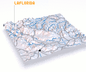 Places with similar names to La Florida, Mexico ::
// La Florida (PA)
// La Florida (PA)
// La Florida (PA)
// La Florida (ES)
// La Florida (ES)
// La Florida (ES)
// La Florida (ES)
// La Florida (ES)
// La Florida (CL)
// La Florida (CL)
Disclaimer :: Information on this page comes without warranty of any kind |
||
|
Where is La Florida? Elevation and coordinates ::
Latitude (lat): 20°33'0"N Longitude (lon): 98°59'0"W
Elevation (approx.): 1878m (map arrows pan, magnifying glasses zoom) |
||
|
Visiting La Florida? Hotel/Accommodation ::
Book a hotel in La Florida Travel Guide ::
Buy a travel guide for Mexico rental cars ::
car rental offers GPS waypoint ::
download a GPX waypoint (PoI) of La Florida for your GPS receiver
|
||