|
search place name
|
||
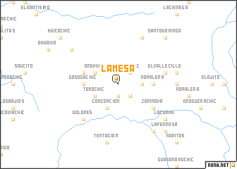
La Mesa (Chihuahua, Mexico)La Mesa is a town in the Chihuahua region of Mexico. An overview map of the region around La Mesa is displayed below.
regional and 3d topo map of La Mesa, Mexico ::
La Mesa airports ::
The nearest airport is CEN - Ciudad Obregon Intl, located 164.3 km west of La Mesa.
Nearby towns ::
El Crestón (1.9km south) //
Uruáchic (2.5km north east) //
Los Alisos (2.5km south east) //
La Nopalera (3.3km east) //
Oro Vivo (3.8km north west) //
Torochic (3.8km south west) //
Concepción (4.1km south west) //
Gosogachic (4.9km west) //
Nopalera (4.9km east) //
Gasogachic (5.3km west) //
Zorinova (6.2km south east) //
El Vallecillo (6.8km east) //
Dolores (7.4km south west) //
La Tableta (8.1km north east) //
Jicamórachic (8.6km north west) //
La Cueva (8.6km south east) //
Guaguihivo (8.9km south east) //
Santo Domingo (9.9km north east) //
La Ferrosa (9.9km south east) //
[all distances 'as the bird flies' and approximate] 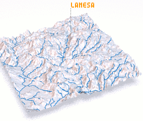 Places with similar names to La Mesa, Mexico ::
Disclaimer :: Information on this page comes without warranty of any kind |
||
|
Where is La Mesa? Elevation and coordinates ::
Latitude (lat): 27°51'0"N Longitude (lon): 108°15'0"W
Elevation (approx.): 1567m (map arrows pan, magnifying glasses zoom) |
||
|
Visiting La Mesa? Hotel/Accommodation ::
Book a hotel in La Mesa Travel Guide ::
Buy a travel guide for Mexico rental cars ::
car rental offers GPS waypoint ::
download a GPX waypoint (PoI) of La Mesa for your GPS receiver
|
||