|
search place name
|
||
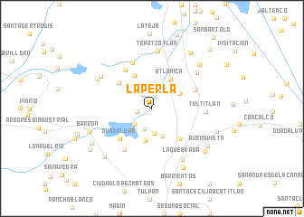
La Perla (México, Mexico)La Perla is a town in the México region of Mexico. An overview map of the region around La Perla is displayed below.
regional and 3d topo map of La Perla, Mexico ::
La Perla airports ::
The nearest airport is MEX - Mexico City Licenciado Benito Juarez Intl, located 29.0 km south east of La Perla.
Other airports nearby include TLC - Toluca Licenciado Adolfo Lopez Mateos Intl (49.4 km south west), PCA - Pachuca Ingeniero Juan Guillermo Villasana (66.6 km north east), CVJ - Cuernavaca General Mariano Matamoros (90.4 km south), PBC - Puebla Hermanos Serdan Intl (105.4 km south east), Nearby towns ::
Cuautitlán Izcalli (1.7km west) //
La Piedad (2.0km north west) //
La Aurora (2.4km north east) //
Buenavista (2.5km north) //
Lago de Guadalupe (2.6km south) //
Emiliano Zapata (2.8km south west) //
Granjas Unidas (3.1km south) //
Plan de Guadalupe (3.7km south) //
Acamoa (3.7km north east) //
Cárdenas (3.7km north east) //
Tres de Mayo (4.1km south) //
Atlamica (4.2km north east) //
Huilango (4.5km north west) //
Tepalcapa (4.9km south east) //
El Rosario (4.9km north west) //
Guadalupe (5.3km south west) //
Santa Cruz (5.6km north west) //
Cuautitlán (5.5km north east) //
San Mateo Xoloc (6.1km north) //
Emiliano Zapata (6.0km south west) //
Tultitlán (6.3km east) //
San Sebastían Xhala (6.8km north east) //
Tepotzotlán (7.1km north) //
La Quebrada (7.2km south east) //
Santiago Cuautlalpan (7.1km north west) //
Malpan (7.4km north west) //
San Mateo Ixtacalco (7.7km north east) //
Barrón (7.8km west) //
Buenavista (7.9km south east) //
[all distances 'as the bird flies' and approximate]  Places with similar names to La Perla, Mexico ::
// La Perla (PH)
// La Praille (CH)
// La Perla (CU)
// La Perla (CU)
// La Perla (CU)
// La Parrilla (ES)
// La Parrilla (ES)
// La Parrilla (ES)
// La Peral (ES)
// La Peral (ES)
Disclaimer :: Information on this page comes without warranty of any kind |
||
|
Where is La Perla? Elevation and coordinates ::
Latitude (lat): 19°39'2"N Longitude (lon): 99°13'50"W
Elevation (approx.): 2278m (map arrows pan, magnifying glasses zoom) |
||
|
Visiting La Perla? Hotel/Accommodation ::
Book a hotel in La Perla Travel Guide ::
Buy a travel guide for Mexico rental cars ::
car rental offers GPS waypoint ::
download a GPX waypoint (PoI) of La Perla for your GPS receiver
|
||