|
search place name
|
||
La Petrolera (Distrito Federal, Mexico)La Petrolera is a town in the Distrito Federal region of Mexico. An overview map of the region around La Petrolera is displayed below.
regional and 3d topo map of La Petrolera, Mexico ::

La Petrolera airports ::
The nearest airport is MEX - Mexico City Licenciado Benito Juarez Intl, located 14.4 km east of La Petrolera.
Other airports nearby include TLC - Toluca Licenciado Adolfo Lopez Mateos Intl (41.7 km south west), CVJ - Cuernavaca General Mariano Matamoros (72.1 km south), PCA - Pachuca Ingeniero Juan Guillermo Villasana (79.0 km north east), PBC - Puebla Hermanos Serdan Intl (94.2 km east), Nearby towns ::
Santa Cruz Acayucan (0.0km north) //
La Preciosa (0.0km north) //
San Miguel Amantla (1.9km south) //
Azcapotzalco (1.8km east) //
San Álvaro (2.5km south east) //
Ahuixotla Prolongación (2.5km south west) //
El Cristo (2.5km north west) //
Reinosa Tamaulipas (2.5km north east) //
Santa Cruz Acatlán (3.5km west) //
San Jerónimo Tepetlacalco (3.7km north) //
Huizachal (3.8km south) //
Cosmopolita (4.0km south east) //
Nueva Santa María (4.0km south east) //
El Gas (4.0km south east) //
Obrero Popular (4.0km south east) //
Tlatilco (4.0km south east) //
La Florida (4.0km north west) //
Vista Hermosa (4.1km north west) //
Naucalpan de Juárez (4.0km west) //
San Antonio Zomeyucan (5.1km south west) //
Tlalnepantla (5.4km north west) //
San Mateo Nopala (5.2km west) //
Magdalena de las Salinas (5.2km east) //
Euzkadi (5.2km east) //
Pro-Hogar (5.2km east) //
Seguro Social (5.6km north) //
Trabajadores del Hierro (5.2km east) //
Panamericana (5.2km east) //
Defensores de la República (5.2km east) //
[all distances 'as the bird flies' and approximate] 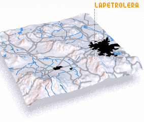 Places with similar names to La Petrolera, Mexico ::
// La Petrolera (BO)
Disclaimer :: Information on this page comes without warranty of any kind |
||
|
Where is La Petrolera? Elevation and coordinates ::
Latitude (lat): 19°29'0"N Longitude (lon): 99°12'0"W
Elevation (approx.): 2255m (map arrows pan, magnifying glasses zoom) |
||
|
Visiting La Petrolera? Hotel/Accommodation ::
Book a hotel in La Petrolera Travel Guide ::
Buy a travel guide for Mexico rental cars ::
car rental offers GPS waypoint ::
download a GPX waypoint (PoI) of La Petrolera for your GPS receiver
|
||