|
search place name
|
||
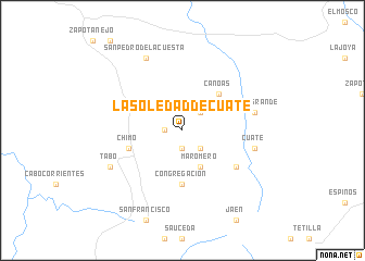
La Soledad de Cuate (Jalisco, Mexico)La Soledad de Cuate is a town in the Jalisco region of Mexico. An overview map of the region around La Soledad de Cuate is displayed below.
regional and 3d topo map of La Soledad de Cuate, Mexico ::
La Soledad de Cuate airports ::
The nearest airport is PVR - Puerto Vallarta Licenciado Gustavo Diaz Ordaz Intl, located 29.6 km north west of La Soledad de Cuate.
Other airports nearby include TPQ - Tepic (108.4 km north), ZLO - Manzanillo Playa De Oro Intl (156.3 km south), GDL - Guadalajara Don Miguel Hidalgo Y Costilla Intl (185.0 km east), CLQ - Colima (205.5 km south east), Nearby towns ::
Lobos (1.7km west) //
San Juan (1.9km south) //
El Carrizal (2.5km north east) //
Refugio de Suchitán (2.5km south east) //
Maromero (4.1km south east) //
Canoas (5.1km north east) //
Congregación (5.6km south) //
Chimo (5.5km west) //
El Zapote (6.4km south east) //
Llano Grande (7.2km east) //
Cuate (7.2km east) //
San Pedro de la Cuesta (8.2km north west) //
Tabo (7.9km south west) //
[all distances 'as the bird flies' and approximate] 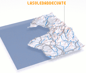 Places with similar names to La Soledad de Cuate, Mexico :: Disclaimer :: Information on this page comes without warranty of any kind |
||
|
Where is La Soledad de Cuate? Elevation and coordinates ::
Latitude (lat): 20°28'0"N Longitude (lon): 105°5'0"W
Elevation (approx.): 1167m (map arrows pan, magnifying glasses zoom) |
||
|
Visiting La Soledad de Cuate? Hotel/Accommodation ::
Book a hotel in La Soledad de Cuate Travel Guide ::
Buy a travel guide for Mexico rental cars ::
car rental offers GPS waypoint ::
download a GPX waypoint (PoI) of La Soledad de Cuate for your GPS receiver
|
||