|
search place name
|
||
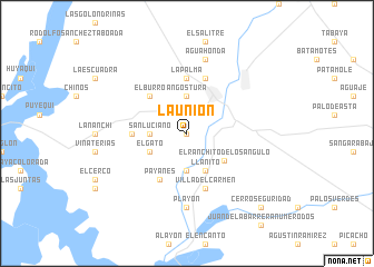
La Unión (Sinaloa, Mexico)La Unión is a town in the Sinaloa region of Mexico. An overview map of the region around La Unión is displayed below.
regional and 3d topo map of La Unión, Mexico ::
La Unión airports ::
The nearest airport is CUL - Culiacan Intl, located 95.3 km south east of La Unión.
Other airports nearby include LMM - Los Mochis Valle Del Fuerte Intl (98.3 km north west), Nearby towns ::
Chumpilihuiste (0.0km north) //
El Saucito (3.7km south) //
Angostura (3.7km north) //
San Luciano (3.4km west) //
Llanito (4.1km south east) //
El Gato (3.8km south west) //
El Ranchito de los Angulo (4.4km south east) //
El Burro (5.0km north west) //
Payanes (5.3km south west) //
Quelite (5.0km west) //
La Palma (5.6km north) //
Villa del Carmen (5.8km south) //
Alhuey (5.8km north) //
Playón (7.4km south) //
Agua Honda (7.6km north) //
Cerro Seguridad (10.0km south east) //
[all distances 'as the bird flies' and approximate] 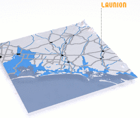 Places with similar names to La Unión, Mexico ::
Disclaimer :: Information on this page comes without warranty of any kind |
||
|
Where is La Unión? Elevation and coordinates ::
Latitude (lat): 25°20'0"N Longitude (lon): 108°11'0"W
Elevation (approx.): 25m (map arrows pan, magnifying glasses zoom) |
||
|
Visiting La Unión? Hotel/Accommodation ::
Book a hotel in La Unión Travel Guide ::
Buy a travel guide for Mexico rental cars ::
car rental offers GPS waypoint ::
download a GPX waypoint (PoI) of La Unión for your GPS receiver
|
||