|
search place name
|
||
Ledesma (Coahuila de Zaragoza, Mexico)Ledesma is a town in the Coahuila de Zaragoza region of Mexico. An overview map of the region around Ledesma is displayed below.
regional and 3d topo map of Ledesma, Mexico ::

Ledesma airports ::
The nearest airport is SLW - Saltillo Plan De Guadalupe Intl, located 77.5 km north of Ledesma.
Other airports nearby include MTY - Monterrey General Mariano Escobedo Intl (131.3 km north east), NTR - Monterrey Del Norte Intl (131.7 km north east), CVM - Ciudad Victoria General Pedro Jose Mendez Intl (236.1 km south east), ZCL - Zacatecas General Leobardo C Ruiz Intl (281.6 km south west), Nearby towns ::
San Juan Bautista (1.7km east) //
Refugio de Altamira (3.8km south west) //
La Campana (5.0km south east) //
Jesús María (6.5km south west) //
Jabalí (6.5km north east) //
San Antonio de las Cruces (7.0km west) //
San José de Guzmán (7.6km south) //
Zacatera (7.5km north west) //
[all distances 'as the bird flies' and approximate] 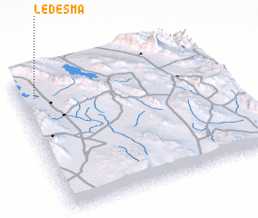 Places with similar names to Ledesma, Mexico ::
Disclaimer :: Information on this page comes without warranty of any kind |
||
|
Where is Ledesma? Elevation and coordinates ::
Latitude (lat): 24°51'0"N Longitude (lon): 100°55'0"W
Elevation (approx.): 1816m (map arrows pan, magnifying glasses zoom) |
||
|
Visiting Ledesma? Hotel/Accommodation ::
Book a hotel in Ledesma Travel Guide ::
Buy a travel guide for Mexico rental cars ::
car rental offers GPS waypoint ::
download a GPX waypoint (PoI) of Ledesma for your GPS receiver
|
||