|
search place name
|
||
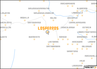
Los Perros (Chihuahua, Mexico)Los Perros is a town in the Chihuahua region of Mexico. An overview map of the region around Los Perros is displayed below.
regional and 3d topo map of Los Perros, Mexico ::
Los Perros airports ::
The nearest airport is CUU - Chihuahua General R Fierro Villalobos Intl, located 205.7 km north of Los Perros.
Nearby towns ::
Santiago (2.5km north east) //
Franqueño (2.5km north east) //
San Francisco del Oro (2.5km north west) //
Capilla (3.7km south) //
Las Toanas (4.1km south east) //
Granadeña (3.8km south east) //
De Enmedio (5.8km north) //
Molino (5.8km north) //
Santa Bárbara (5.8km south) //
Buena Vista (5.3km west) //
Noriega (5.3km east) //
Santo Domingo (6.2km north west) //
Casa Colorada (6.9km east) //
Amparanes (6.9km east) //
San José de los Bailón (7.6km north) //
Papelote (7.6km south east) //
[all distances 'as the bird flies' and approximate] 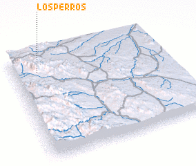 Places with similar names to Los Perros, Mexico ::
// Lee Cypress (US)
// Los Pérez (PA)
// Los Pérez (PA)
// Los Pérez (PA)
// Los Pérez (PA)
// Los Piros (PA)
// Los Piros (PA)
// Las Parras (CU)
// Las Parras (CU)
// Los Perros (CU)
Disclaimer :: Information on this page comes without warranty of any kind |
||
|
Where is Los Perros? Elevation and coordinates ::
Latitude (lat): 26°51'0"N Longitude (lon): 105°50'0"W
Elevation (approx.): 2076m (map arrows pan, magnifying glasses zoom) |
||
|
Visiting Los Perros? Hotel/Accommodation ::
Book a hotel in Los Perros Travel Guide ::
Buy a travel guide for Mexico rental cars ::
car rental offers GPS waypoint ::
download a GPX waypoint (PoI) of Los Perros for your GPS receiver
|
||