|
search place name
|
||
Morelos (Chiapas, Mexico)Morelos is a town in the Chiapas region of Mexico. An overview map of the region around Morelos is displayed below.
regional and 3d topo map of Morelos, Mexico ::

Morelos airports ::
The nearest airport is TGZ - Tuxtla Gutierrez Angel Albino Corzo, located 51.3 km south east of Morelos.
Other airports nearby include VSA - Villahermosa C P A Carlos Rovirosa Intl (146.9 km north east), MTT - Minatitlan (188.1 km north west), CME - Ciudad Del Carmen Intl (267.9 km north east), Nearby towns ::
Paso Hondo (3.3km south east) //
Corinto (3.3km north west) //
El Gavilán (3.3km north west) //
San Luis (3.7km east) //
La Ventosa (3.7km east) //
Ocuilapa (5.3km north east) //
Desvio El Gavilán (5.8km south) //
El Chorrón (6.0km south east) //
El Rosario (6.7km south) //
Rafael A. Zorrilla (7.7km south) //
Ixquipac (8.3km north) //
Bocotzica (8.4km north east) //
Ocozocuautla (8.5km south east) //
Alsacia (8.8km north east) //
Paraje Camacho (9.6km south east) //
Las Pilitas (10.3km south west) //
[all distances 'as the bird flies' and approximate] 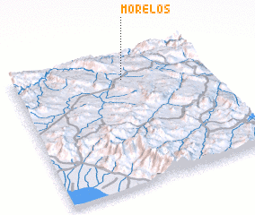 Places with similar names to Morelos, Mexico ::
// Morles (DE)
// Morlesau (DE)
// Maureles (PT)
// Meireles (PT)
// Merlães (PT)
// Mourelos (PT)
// Mourelos (PT)
// María Luisa (CU)
// María Luisa (CU)
// María Luisa (CU)
Disclaimer :: Information on this page comes without warranty of any kind |
||
|
Where is Morelos? Elevation and coordinates ::
Latitude (lat): 16°48'30"N Longitude (lon): 93°26'0"W
Elevation (approx.): 793m (map arrows pan, magnifying glasses zoom) |
||
|
Visiting Morelos? Hotel/Accommodation ::
Book a hotel in Morelos Travel Guide ::
Buy a travel guide for Mexico rental cars ::
car rental offers GPS waypoint ::
download a GPX waypoint (PoI) of Morelos for your GPS receiver
|
||