|
search place name
|
||
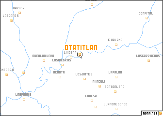
Otatitlán (Durango, Mexico)Otatitlán is a town in the Durango region of Mexico. An overview map of the region around Otatitlán is displayed below.
regional and 3d topo map of Otatitlán, Mexico ::
Otatitlán airports ::
The nearest airport is CUL - Culiacan Intl, located 85.2 km west of Otatitlán.
Other airports nearby include MZT - Mazatlan General Rafael Buelna Intl (171.6 km south), Nearby towns ::
Limosna (2.1km west) //
Las Piedras (4.3km south west) //
Los Jiotes (4.9km south) //
Achota (6.3km south west) //
Amaculí (7.5km south east) //
Igualamo (7.9km north east) //
Pueblo Nuevo (7.9km west) //
La Palma (8.5km south east) //
Santa Elena (10.5km south east) //
[all distances 'as the bird flies' and approximate] 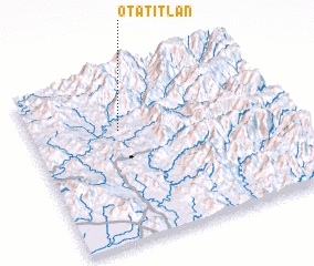 Places with similar names to Otatitlán, Mexico ::
// Otatitlán (MX)
Disclaimer :: Information on this page comes without warranty of any kind |
||
|
Where is Otatitlán? Elevation and coordinates ::
Latitude (lat): 24°40'21"N Longitude (lon): 106°38'19"W
Elevation (approx.): 274m (map arrows pan, magnifying glasses zoom) |
||
|
Visiting Otatitlán? Hotel/Accommodation ::
Book a hotel in Otatitlán Travel Guide ::
Buy a travel guide for Mexico rental cars ::
car rental offers GPS waypoint ::
download a GPX waypoint (PoI) of Otatitlán for your GPS receiver
|
||